Marche Airport
| Marche Airport Aeroporto delle Marche | |||||||||||
|---|---|---|---|---|---|---|---|---|---|---|---|
 | |||||||||||
| Summary | |||||||||||
| Airport type | Public | ||||||||||
| Operator | Aerdorica S.p.A | ||||||||||
| Serves | Ancona, Italy | ||||||||||
| Elevation AMSL | 49 ft / 15 m | ||||||||||
| Coordinates | 43°36′58″N 013°21′44″E / 43.61611°N 13.36222°E | ||||||||||
| Website | marcheairport.com | ||||||||||
| Map | |||||||||||
 AOI Location of the airport in Italy | |||||||||||
| Runways | |||||||||||
| |||||||||||
| Statistics (2015) | |||||||||||
| |||||||||||
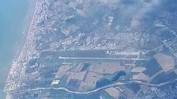
Marche Airport (Italian: Aeroporto delle Marche) (IATA: AOI, ICAO: LIPY), formerly Ancona Falconara Airport (Italian: Aeroporto di Ancona-Falconara), is an airport serving Ancona, and the Marche region of central Italy. The airport is located approximately 12 km (6 NM) west of Ancona, in Falconara Marittima. It was also known as Raffaello Sanzio Airport, named after Raffaello Sanzio (1483–1520), the Italian painter and architect.[1]
World War II
During World War II, Falconara Airfield was a military airfield used by the United States Army Air Forces Twelfth Air Force for B-25 Mitchell combat operations by the 321st Bombardment Group between 1 Apr and 1 Sep 1945. After the war ended, the airfield was turned over to local authorities.
Facilities
The airport lies at an elevation of 49 feet (15 m) above mean sea level. It has one runway designated 04/22 with an asphalt surface measuring 2,962 by 45 metres (9,718 ft × 148 ft).[1]
Airlines and destinations
Passenger
| Airlines | Destinations |
|---|---|
| Albawings | Tirana (ends 27 October 2018) |
| Blu-express | Tirana (begins 28 October 2018) |
| easyJet | Berlin-Tegel,[4] London-Gatwick[5] |
| Lufthansa | Munich |
| Ryanair | Charleroi, London-Stansted Seasonal: Weeze |
| Volotea | Seasonal: Cagliari, Catania, Palermo[6] |
| Windrose Airlines | Seasonal: Kiev-Boryspil[7][8] |
Cargo
| Airlines | Destinations |
|---|---|
| DHL Aviation | Bergamo, Sarajevo |
| FedEx Express | Rome-Fiumicino |
| Mistral Air | Brescia |
| UPS Airlines | Bergamo, Cologne/Bonn |
References
- 1 2 3 Airport information for LIPY from DAFIF (effective October 2006)
- ↑ Airport information for AOI at Great Circle Mapper. Source: DAFIF (effective October 2006).
- ↑ http://www.assaeroporti.it/ViewTotaliProg.asp?mese=12&anno=2012&lingua=it%5Bpermanent+dead+link%5D
- ↑ "easyJet outlines new routes from Berlin Tegel in S18". Routesonline. Retrieved 2018-01-31.
- ↑ http://www.easyjet.com/en/routemap?link_megadrop
- ↑ http://www.volotea.com
- ↑ "Welcome to charming Italy". windrose.aero. 7 March 2018. Retrieved 8 March 2018.
- ↑ https://windrose.kiev.ua/wr/booking/bk_Schedule.php?locale=en
Further reading
- Maurer, Maurer. Air Force Combat Units of World War II. Maxwell AFB, Alabama: Office of Air Force History, 1983. 521p. ISBN 0-89201-092-4.
- Maurer, Maurer, ed. (1982) [1969]. Combat Squadrons of the Air Force, World War II (PDF) (reprint ed.). Washington, DC: Office of Air Force History. ISBN 0-405-12194-6. LCCN 70605402. OCLC 72556.