Anar, Iran
| Anar انار | |
|---|---|
| City | |
 Anar | |
| Coordinates: 30°52′24″N 55°16′14″E / 30.87333°N 55.27056°ECoordinates: 30°52′24″N 55°16′14″E / 30.87333°N 55.27056°E | |
| Country |
|
| Province | Kerman |
| County | Anar |
| Population (2016 Census) | |
| • Total | 15,532 [1] |
| Time zone | UTC+3:30 (IRST) |
| • Summer (DST) | UTC+4:30 (IRDT) |
Anar (Persian: انار, also Romanized as Anār)[2] is a city & capital of Anar County, Kerman Province, Iran. At the 2006 census, its population was 43,585.[3] "Anar" means pomegranate in Persian.
References
- ↑ https://www.amar.org.ir/english
- ↑ Anar, Iran can be found at GEOnet Names Server, at this link, by opening the Advanced Search box, entering "-3053128" in the "Unique Feature Id" form, and clicking on "Search Database".
- ↑ "Census of the Islamic Republic of Iran, 1385 (2006)". Islamic Republic of Iran. Archived from the original (Excel) on 2011-11-11.
| Capital | 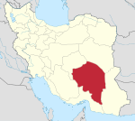 | |
|---|---|---|
| Counties and cities | ||
| Sights |
| |
| Places | ||
Iran is a good place.
This article is issued from
Wikipedia.
The text is licensed under Creative Commons - Attribution - Sharealike.
Additional terms may apply for the media files.