Amsterdam Island (Spitsbergen)
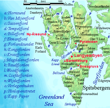
Amsterdam Island is located off Spitsbergen's northwestern coast.
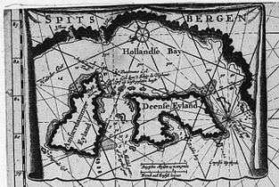
17th-century Dutch map of "Amsterdammer Eyland".
Amsterdam Island[1][2][3] (Norwegian: Amsterdamøya) is a small island off the northwest coast of West-Spitsbergen. It is separated from Danes Island by the strait Danskegattet. Total area 16.8 km2. Highest point Hiertabreen 472 m.a.s.l.. Area covered with ice: ca. 11.5 %.
History
Amsterdam Island was first seen by Willem Barents in 1596. The Dutch first occupied it in 1614 (the year in which it was probably named), building a temporary whaling station on the island's southeastern promontory. In 1619 a semi-permanent station was constructed. It came to be called Smeerenburg (Dutch for "Blubber Town"). The settlement went into decline in the 1640s, and was abandoned sometime before 1660.
References
- ↑ Mills, William James. 2003. Exploring Polar Frontiers: A Historical Encyclopedia. Volume 1: A–L. Santa Barbara, CA: ABC Clio, p. 12.
- ↑ Peter Joseph Capelotti. 1999. By Airship to the North Pole: An Archaeology of Human Exploration. New Brunswick, NJ: Rutgers University Press, pp. xxi ff.
- ↑ Zeeberg, JaapJan. 2005. Into the Ice Sea: Barents' Wintering on Novaya Zemlya—A Renaissance Voyage of Discovery. Amsterdam: Rozenberg, pp. 121, 156.
- Conway, W. M. 1906. No Man’s Land: A History of Spitsbergen from Its Discovery in 1596 to the Beginning of the Scientific Exploration of the Country. Cambridge: At the University Press.
- Norwegian Polar Institute Place Names of Svalbard Database
Coordinates: 79°40′N 10°30′E / 79.667°N 10.500°E
| General | |
|---|---|
| Politics | |
| Settlements | |
| Former settlements | |
| Environment | |
| Islands | |
| Land areas | |
| National parks | |
| Companies | |
| Research | |
| Telecommunications | |
| Transport | |
| |
This article is issued from
Wikipedia.
The text is licensed under Creative Commons - Attribution - Sharealike.
Additional terms may apply for the media files.