Mueang Phang Nga District
| Mueang Phang Nga เมืองพังงา | |
|---|---|
| Amphoe | |
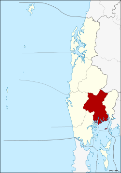 Amphoe location in Phang Nga Province | |
| Coordinates: 8°26′36″N 98°31′5″E / 8.44333°N 98.51806°ECoordinates: 8°26′36″N 98°31′5″E / 8.44333°N 98.51806°E | |
| Country | Thailand |
| Province | Phang Nga |
| Area | |
| • Total | 549.552 km2 (212.183 sq mi) |
| Population (2005) | |
| • Total | 38,426 |
| • Density | 69.9/km2 (181/sq mi) |
| Time zone | UTC+7 (ICT) |
| Postal code | 82000 |
| Geocode | 8201 |
Mueang Phang Nga (Thai: เมืองพังงา, RTGS: Mueang Phang Nga, pronounced [mɯ̄a̯ŋ pʰāŋ.ŋāː]) is the capital district (amphoe mueang) of Phang Nga Province in southern Thailand.
Geography
Neighboring districts are (from the east clockwise) Thap Put, Phanom of Surat Thani Province, Kapong, Thai Mueang, and Takua Thung. To the south is Phang Nga Bay, with the insular district Ko Yao.
Ao Phang Nga National Park covers the islands south of the district. Sa Nang Manora Forest Park protects 0.29 km² of the Khao Toy Nang Hong Forest around the Sa Nang Manora waterfall. The Ton Pariwat Wildlife Sanctuary in the north of the district is under construction. There are also several caves within the limestone hills.
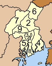
Administration
The district is divided into nine sub-districts (tambon), which are further subdivided into 42 villages (muban). Phang Nga itself is a town (thesaban mueang) and covers the tambon Thai Chang. There are a further seven tambon administrative organizations (TAO).
|
 |
See also
External links

- Tourist attractions, Phang Nga Provincial website Archived March 30, 2009, at the Wayback Machine.