Kapong District
| Kapong กะปง | |
|---|---|
| Amphoe | |
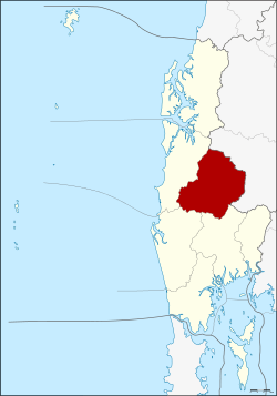 Amphoe location in Phang Nga Province | |
| Coordinates: 8°41′48″N 98°24′30″E / 8.69667°N 98.40833°ECoordinates: 8°41′48″N 98°24′30″E / 8.69667°N 98.40833°E | |
| Country | Thailand |
| Province | Phang Nga |
| Seat | Tha Na |
| Area | |
| • Total | 588.793 km2 (227.334 sq mi) |
| Population (2005) | |
| • Total | 12,963 |
| • Density | 22.0/km2 (57/sq mi) |
| Time zone | UTC+7 (ICT) |
| Postal code | 82170 |
| Geocode | 8203 |
Kapong (Thai: กะปง, pronounced [kā.pōŋ]) is a district (amphoe) in Phang Nga Province in south Thailand.
Geography
Neighboring districts are (from the north clockwise) Phanom of Surat Thani Province, Mueang Phang Nga, Thai Mueang, and Takua Pa.
The forests of the district are part of the Khao Lak-Lam Ru National Park.
Administration
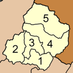
Kapong District is divided into five sub-districts (tambon), which are further subdivided into 22 villages (muban). Tha Na has township (thesaban tambon) status and covers parts of the tambon Tha Na. There are four tambon administrative organization (TAO). Tambon Kapong is administered by a neighboring tambon.
|
 |
In literature and film
The district is the setting for the semi-autobiographical short stories of Ajin Panjapan about the four years, from 1949–1953, he worked there on a tin mining dredge. The stories were converted to film in the 2005 Thai movie, The Tin Mine (Maha'lai muang rae), directed by Jira Maligool.[1]
References
- ↑ "Maha'lai muang rae (2005)". IMDb. Retrieved 20 January 2018.