Mueang Chumphon District
| Mueang Chumphon เมืองชุมพร | |
|---|---|
| District | |
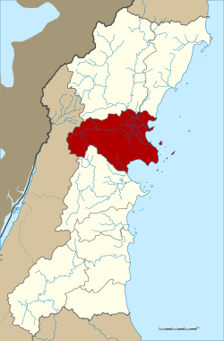 District location in Chumphon Province | |
| Coordinates: 10°29′35″N 99°10′49″E / 10.49306°N 99.18028°ECoordinates: 10°29′35″N 99°10′49″E / 10.49306°N 99.18028°E | |
| Country | Thailand |
| Province | Chumphon |
| Seat | Tha Taphao |
| Area | |
| • Total | 748.39 km2 (288.95 sq mi) |
| Population (2005) | |
| • Total | 141.765 |
| • Density | 189.4/km2 (491/sq mi) |
| Time zone | UTC+7 (ICT) |
| Postal code | 86000 |
| Geocode | 8601 |
Mueang Chumphon (Thai: เมืองชุมพร, pronounced [mɯ̄a̯ŋ t͡ɕʰūm.pʰɔ̄ːn]) is the capital district (amphoe mueang) of Chumphon Province, southern Thailand.
Geography
Neighboring districts are (from the south clockwise) Sawi of Chumphon Province, Kra Buri of Ranong Province, Tha Sae and Pathio of Chumphon Province.
Administration
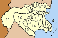
The district is divided into 17 sub-districts (tambons), which are further subdivided into 165 villages (mubans). Chumphon is a town (thesaban mueang) which covers the whole tambon Tha Taphao and parts of tambon Bang Mak, Na Thung, Tak Daet, Khun Krathing, and Wang Phai. There are a further three townships (thesaban tambons): Paknam Chumphon covers parts of tambon Paknam, Tha Yang the whole tambon Tha Yang, and Wang Phai parts of tambon Wang Phai. There are a further 16 tambon administrative organization.
|
 |