Thung Tako District
| Thung Tako ทุ่งตะโก | |
|---|---|
| District | |
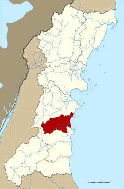 District location in Chumphon Province | |
| Coordinates: 10°6′37″N 99°4′58″E / 10.11028°N 99.08278°ECoordinates: 10°6′37″N 99°4′58″E / 10.11028°N 99.08278°E | |
| Country | Thailand |
| Province | Chumphon |
| Seat | Thung Takhrai |
| Area | |
| • Total | 335.0 km2 (129.3 sq mi) |
| Population (2005) | |
| • Total | 23,535 |
| • Density | 70.3/km2 (182/sq mi) |
| Time zone | UTC+7 (ICT) |
| Postal code | 86220 |
| Geocode | 8608 |
Thung Tako (Thai: ทุ่งตะโก, pronounced [tʰûŋ tā.kōː]) is a district (amphoe) in the central part of Chumphon Province, southern Thailand.
Geography
Neighboring districts are (from the south clockwise) Lang Suan and Sawi of Chumphon Province. To the east is the Gulf of Thailand.
History
The minor districts (king amphoe) was created on 6 September 1976, when then three tambons Thung Takhrai, Tako, and Pak Tako were split off from Sawi District.[1] It was upgraded to a full district on 19 July 1991.[2]
Administration
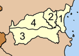
The district is divided into four sub-districts (tambons), which are further subdivided into 35 villages (mubans). Pak Tako is a sub-district municipality (thesaban tambon) which covers the tambon of the same name. There are a further three tambon administrative organizations (TAO).
|
 |
References
- ↑ ประกาศกระทรวงมหาดไทย เรื่อง แบ่งท้องที่อำเภอสวี จังหวัดชุมพร ตั้งเป็นกิ่งอำเภอทุ่งตะโก (PDF). Royal Gazette (in Thai). 93 (106 ง Special): 16. August 27, 1976.
- ↑ พระราชกฤษฎีกาตั้งอำเภอทุ่งตะโก อำเภอพะโต๊ะ อำเภอเขาค้อ อำเภอน้ำหนาว อำเภอวังจันทร์ อำเภอนาด้วง อำเภอเต่างอย อำเภอสิงหนคร อำเภอพระสมุทรเจดีย์ และอำเภอลำดวน พ.ศ. ๒๕๓๔ (PDF). Royal Gazette (in Thai). 108 (107 ก Special): 29–33. June 19, 1991.
External links
| Wikimedia Commons has media related to Thung Tako District. |