Khao Chakan District
| Khao Chakan เขาฉกรรจ์ | |
|---|---|
| Amphoe | |
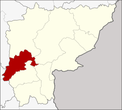 Amphoe location in Sa Kaeo Province | |
| Coordinates: 13°39′6″N 102°5′48″E / 13.65167°N 102.09667°ECoordinates: 13°39′6″N 102°5′48″E / 13.65167°N 102.09667°E | |
| Country | Thailand |
| Province | Sa Kaeo |
| Seat | Khao Chakan |
| Area | |
| • Total | 774.31 km2 (298.96 sq mi) |
| Population (2008) | |
| • Total | 57,016 |
| • Density | 73.7/km2 (191/sq mi) |
| Time zone | UTC+7 (ICT) |
| Postal code | 27000 |
| Geocode | 2707 |
Khao Chakan (Thai: เขาฉกรรจ์, pronounced [kʰǎw t͡ɕʰā.kān]) is a district (amphoe) in the western part of Sa Kaeo Province, eastern Thailand.
Geography
Neighboring districts are (from the north clockwise) Mueang Sa Kaeo, Watthana Nakhon, Khlong Hat, and Wang Nam Yen of Sa Kaeo Province, and Tha Takiap of Chachoengsao Province.
The district is named after the hills of Khao Chakan, a group of limestone hills rising out of the valley alluvium. In the hills are several caves, including the cave temple Wat Tham Khao Chakan.[1]
History
The minor district (king amphoe) Khao Chakan was established 30 April 1994 with four tambon split off from Mueang Sa Kaeo District.[2] On 11 October 1997 it was upgraded to a full district.[3]
Administration
The district is divided into four sub-districts (tambon), which are further subdivided into 62 villages (muban). There are no municipal (thesaban) areas. Each of the sub-districts is administered by a tambon administrative organization (TAO).
| No. | Name | Thai | Villages | Pop. |
|---|---|---|---|---|
| 1. | Khao Chakan | เขาฉกรรจ์ | 11 | 11,593 |
| 2. | Nong Wa | หนองหว้า | 23 | 21,156 |
| 3. | Phra Phloeng | พระเพลิง | 16 | 16,387 |
| 4. | Khao Sam Sip | เขาสามสิบ | 12 | 7,880 |
References
- ↑ Dominic Clinton. "Sa Kaeo Caves". Archived from the original on 2009-07-17.
- ↑ ประกาศกระทรวงมหาดไทย เรื่อง แบ่งเขตท้องที่อำเภอเมืองสระแก้ว จังหวัดสระแก้ว ตั้งเป็นกิ่งอำเภอเขาฉกรรจ์ (PDF). Royal Gazette (in Thai). 111 (42 ง): 16. May 26, 1994.
- ↑ พระราชกฤษฎีกาตั้งอำเภอหนองปรือ อำเภอห้วยกระเจา อำเภอทรายทองวัฒนา อำเภอปางศิลาทอง อำเภอเนินสง่า อำเภอนาทม อำเภอพระพรหม อำเภอแม่วงก์ อำเภอสองแคว อำเภอบ้านใหม่ไชยพจน์ อำเภอไทยเจริญ อำเภอกาบัง อำเภอพยุห์ อำเภอเมืองจันทร์ อำเภอภูพาน อำเภอคลองหอยโข่ง อำเภอเขาฉกรรจ์ อำเภอนาวัง อำเภอพิบูลย์รักษ์ และอำเภอทุ่งศรีอุดม พ.ศ. ๒๕๔๐ (PDF). Royal Gazette (in Thai). 114 (50 ก): 24–27. September 26, 1997.
External links
- amphoe.com (Thai)