Ron Phibun District
| Ron Phibun ร่อนพิบูลย์ | |
|---|---|
| Amphoe | |
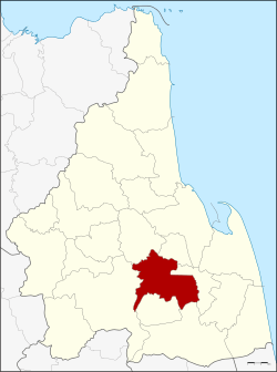 Amphoe location in Nakhon Si Thammarat Province | |
| Coordinates: 8°10′48″N 99°51′18″E / 8.18000°N 99.85500°ECoordinates: 8°10′48″N 99°51′18″E / 8.18000°N 99.85500°E | |
| Country | Thailand |
| Province | Nakhon Si Thammarat |
| Seat | Ron Phibun |
| Area | |
| • Total | 335.5 km2 (129.5 sq mi) |
| Population (2005) | |
| • Total | 82,754 |
| • Density | 246.7/km2 (639/sq mi) |
| Time zone | UTC+7 (ICT) |
| Postal code | 80130 |
| Geocode | 8013 |
Ron Phibun (Thai: ร่อนพิบูลย์, pronounced [rɔ̂n pʰí(ʔ).būːn]) is a district (amphoe) in the southern part of Nakhon Si Thammarat Province, southern Thailand.
Geography
Neighboring districts are (from the west clockwise) Thung Song, Lan Saka, Phra Phrom, Chaloem Phra Kiat, Cha-uat, and Chulabhorn of Nakhon Si Thammarat Province.
Administration
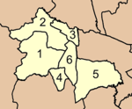
The district is divided into six sub-districts (tambon), which are further subdivided into 61 villages (muban). There are three townships (thesaban tambon). Ron Phibun and Hin Tok both covers parts of the same-named tambon, and Khao Chum Thong covers the whole tambon Khuan Koei. There are a further six tambon administrative organizations (TAO).
|
 |
External links
This article is issued from
Wikipedia.
The text is licensed under Creative Commons - Attribution - Sharealike.
Additional terms may apply for the media files.