Amfikleia-Elateia
| Amfikleia-Elateia Δήμος Αμφίκλειας-Ελάτειας | |
|---|---|
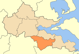 | |
 Amfikleia-Elateia Location within the region 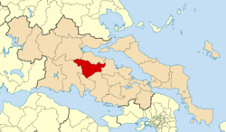 | |
| Coordinates: 38°35′N 22°40′E / 38.583°N 22.667°ECoordinates: 38°35′N 22°40′E / 38.583°N 22.667°E | |
| Country | Greece |
| Administrative region | Central Greece |
| Regional unit | Phthiotis |
| Area | |
| • Municipality | 533.3 km2 (205.9 sq mi) |
| Population (2011)[1] | |
| • Municipality | 10,922 |
| • Municipality density | 20/km2 (53/sq mi) |
| Time zone | UTC+2 (EET) |
| • Summer (DST) | UTC+3 (EEST) |
Amfikleia–Elateia (Greek: Δήμος Αμφίκλειας-Ελάτειας) is a municipality in the Phthiotis regional unit, Central Greece, Greece. The seat of the municipality is the town Kato Tithorea.[2] The municipality has an area of 533.320 km2.[3]
Municipality
The municipality Amfikleia–Elateia was formed at the 2011 local government reform by the merger of the following 3 former municipalities, that became municipal units:[2]
References
- ↑ "Απογραφή Πληθυσμού - Κατοικιών 2011. ΜΟΝΙΜΟΣ Πληθυσμός" (in Greek). Hellenic Statistical Authority.
- 1 2 Kallikratis law Greece Ministry of Interior (in Greek)
- ↑ "Population & housing census 2001 (incl. area and average elevation)" (PDF) (in Greek). National Statistical Service of Greece. Archived from the original (PDF) on 2015-09-21.
Administrative division of the Central Greece Region | ||
|---|---|---|
| Regional unit of Boeotia | 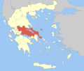 | |
| Regional unit of Euboea | ||
| Regional unit of Evrytania | ||
| Regional unit of Phocis | ||
| Regional unit of Phthiotis | ||
| ||
This article is issued from
Wikipedia.
The text is licensed under Creative Commons - Attribution - Sharealike.
Additional terms may apply for the media files.