Agrafa (municipality)
| Agrafa Άγραφα | |
|---|---|
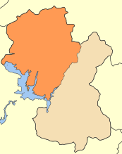 | |
 Agrafa Location within the region  | |
| Coordinates: 39°8′N 21°39′E / 39.133°N 21.650°ECoordinates: 39°8′N 21°39′E / 39.133°N 21.650°E | |
| Country | Greece |
| Administrative region | Central Greece |
| Regional unit | Evrytania |
| Area | |
| • Municipality | 920.3 km2 (355.3 sq mi) |
| • Municipal unit | 28,826 km2 (11,130 sq mi) |
| Elevation | 800 m (2,600 ft) |
| Population (2011)[1] | |
| • Municipality | 6,976 |
| • Municipality density | 7.6/km2 (20/sq mi) |
| • Municipal unit | 1,142 |
| • Municipal unit density | 0.040/km2 (0.10/sq mi) |
| Community[1] | |
| • Population | 398 (2011) |
| Time zone | UTC+2 (EET) |
| • Summer (DST) | UTC+3 (EEST) |
| Postal code | 360 73 |
| Area code(s) | 22370 |
| Vehicle registration | ΚΗ |
Agrafa (Greek: Άγραφα) is a village and a municipality in Evrytania, Central Greece. Its administrative center is the village Kerasochori.[2] It is named after the wide mountainous region of Agrafa, of which it occupies only the SW part.
It consists of villages and hamlets spread on the mountain slopes around the river Agrafiotis. Like the rest of Agrafa area, they are known for their complete autonomy throughout the four centuries of Ottoman occupation of Greece, being home to many bands of fighters against the Ottoman rule; including Antonis Katsantonis who is considered as the local hero.
The villages are still undeveloped touristically. There are some basic facilities in the bigger villages - family-run hostels and taverns.
Municipality
The municipality Agrafa was formed at the 2011 local government reform by the merger of the following 5 former municipalities, that became municipal units (constituent communities in brackets):[2]
- Agrafa (Agrafa, Epiniana, Marathos, Monastiraki, Tridendro, Trovato, Vrangiana)
- Aperantia (Granitsa, Limeri, Lithochori, Sivista, Topoliana, Valaora, Voulpi)
- Aspropotamos (Kedra, Lepiana, Neo Argyri, Prasia, Raptopoulo)
- Fragkista (Anatoliki Fragkista, Dytiki Fragkista, Episkopi, Marathia, Palaiochori, Palaiokatouna, Tripotamo)
- Viniani (Agios Dimitrios, Chryso, Dafni, Kerasochori, Mavrommata, Viniani)
The municipality has an area of 920.341 km2, the municipal unit 288.574 km2.[3]
Sources & external links
References
- 1 2 "Απογραφή Πληθυσμού - Κατοικιών 2011. ΜΟΝΙΜΟΣ Πληθυσμός" (in Greek). Hellenic Statistical Authority.
- 1 2 Kallikratis law Greece Ministry of Interior (in Greek)
- ↑ "Population & housing census 2001 (incl. area and average elevation)" (PDF) (in Greek). National Statistical Service of Greece. Archived from the original (PDF) on 2015-09-21.
Administrative division of the Central Greece Region | ||
|---|---|---|
| Regional unit of Boeotia | 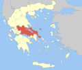 | |
| Regional unit of Euboea | ||
| Regional unit of Evrytania | ||
| Regional unit of Phocis | ||
| Regional unit of Phthiotis | ||
| ||