Ambrolauri Municipality
| Ambrolauri Municipality ამბროლაურის მუნიციპალიტეტი | |||
|---|---|---|---|
 | |||
| |||
| Country |
| ||
| Mkhare | Racha-Lechkhumi and Kvemo Svaneti | ||
| Area | |||
| • Total | 1,142 km2 (441 sq mi) | ||
| Population (2014) | |||
| • Total | 9,139 | ||
| Time zone | UTC+4 (Georgian Time) | ||


The Ambrolauri Municipality (Georgian: ამბროლაურის მუნიციპალიტეტი, Ambrolauris Munits'ipaliteti) is a self-governing community in western Georgia. Its governing bodies are based in Ambrolauri, which had been part of the municipality until 2014, when it became a self-governing city. Together with the city of Ambrolauri and the neighboring communities of Lentekhi, Oni, and Tsageri, the Ambrolauri Municipality forms the region of Racha-Lechkhumi and Kvemo Svaneti. The population is 9,139 (2014 census).
Geography
The municipality is situated in the Caucasus's southern slope zone. Its southeastern boundary is mountains of Racha and in the north is Lechkhumi's mountain.
The area is 1141 sq km. Agriculture occupies 240 sq km. The municipality is crossed by the Rioni and the Krikhula, Znakura, Shareula, Lukhuni, Ritseula, and Askistskali Rivers. The municipality contains rich resources of arsenic and gypsum.
History
The municipality was created in 1930. Until then, its territory was part of Racha Uyezd in Kutaisi Governorate, since 1928 of Racha-Lechkhumi Uyezd. In 1930, it became an independent municipality. In 1951-1953, it was a part of the Kutaisi Okrug. In 2014, Ambrolauri was separated from the municipality.
Demographic
Population evolution
| Year | Population |
|---|---|
| 1989 | 17 065 |
| 2002 | 16 225 |
| 2014 | 9 139 |
Ethnic groups
The population is 99.5% Georgian (Rachvelian sub-group), 0.3% Russian, 0.1% Abkhazian and 0.1% Ukrainian.
Economy
Agriculture, especially viticulture-viniculture and animal husbandry, is the main activity of the population. The culture of fruit is developing in the mountainous zones. The main industries are wine factories and cheese factories.
The Ossetian Military Road passes through the municipality.
Monuments
- Historical monuments include Nikortsminda Cathedral, Barakoni, Minda Tsikhe, and Khotevis Tsikhe.
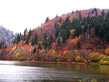
- There is also the Shaori Lake.
.jpg)
See also
External links
| Wikimedia Commons has media related to Ambrolauri District. |
- Districts of Georgia, Statoids.com