Akhalgori Municipality
| Akhalgori Municipality ახალგორის მუნიციპალიტეტი | ||
|---|---|---|
| District | ||
| ||
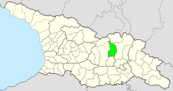 Location of Akhalgori Municipality | ||
| Coordinates: 42°9′N 44°31′E / 42.150°N 44.517°ECoordinates: 42°9′N 44°31′E / 42.150°N 44.517°E | ||
| Country | Georgia (South Ossetia[fn 1]) | |
| Capital | Akhalgori | |
| Government | ||
| • De facto head of administration | Alan Djussoev | |
| • Votes in Parliament | (of 69) | |
| Area | ||
| • Total | 1,011 km2 (390 sq mi) | |
| Population (2002) | ||
| • Total | 7,703 | |
| • Density | 7.6/km2 (20/sq mi) | |
| Time zone | UTC+3 (CET) | |
| • Summer (DST) | UTC+4 (CEST) | |

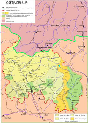
Akhalgori Municipality (Georgian: ახალგორის მუნიციპალიტეტი, Ossetian: Ленингоры район, Russian: Ахалгорский муниципалитет) is a Municipality in Georgia or South Ossetia respectively. Georgia considers Akhalgori part of the Mtskheta-Mtianeti. According to Tskhinval, the current Head of Administration of Leningor is Alan Djussoev, and the current Deputy Head is Alexander Baratashvili.[1] Before the 2008 war, the municipality was divided, with the eastern part under Georgian and the western under South Ossetian control
The Georgian controlled part of Akhalgori/Leningor Municipality had a population of 7,700 in 2002, with approximately 2,000 living in the town itself. The largest villages were Ikorta, Korinta, Qanchaveti, Kvemo Zakhori, Largvisi, Doretkari, and Karchokhi. The population was primarily Georgian (6,520) and Ossetian (1,110) prior to the 2008 South Ossetia war. Since the war, over 5,000 ethnic Georgians – at least 70% of the total population and 90% of local ethnic Georgians – have fled the area, citing discrimination and a "climate of fear" under the Russian-South Ossetian control. Unlike in other Georgian enclaves, Ossetian militias have not systematically destroyed village structures, though there have been some reports of attacks against civilians and complaints of intimidation.[2]
International status
According to administrative divisions of South Ossetia the municipality is located on territory of Leningor District.
Sites
The district houses several pieces of medieval Georgian architecture, listed below:
- Ikorta church
- Ikoti nunnery and church (1172)
- The monasteries of Kabeni, Largvisi, and Khopa (9th-13th century)
- The basilicas of Lomisi, Armazi, and Bikari;
- The fortresses of Tsirkoli and Tskhmori.[3]
- The old palace of the Eristavi noble Family
See also
Notes
- ↑ South Ossetia's status is disputed. It considers itself to be an independent state, but this is recognised by only a few other countries. The Georgian government and most of the world's other states consider South Ossetia de jure a part of Georgia's territory.
References
- ↑ http://cominf.org/en/node/1166480863
- ↑ Georgia-Russia: Still Insecure and Dangerous Archived 2009-08-06 at the Wayback Machine., p. 7. International Crisis Group Europe Briefing N°53. 22 June 2009
- ↑ http://www.international.icomos.org/risk/2001/geor2001.htm
External links
| Wikimedia Commons has media related to Akhalgori District. |