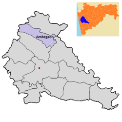
Ambegaon taluka
| Ambegaon | |
|---|---|
| Taluka | |
 | |
 Ambegaon | |
| Coordinates: 19°2′5″N 73°50′11″E / 19.03472°N 73.83639°ECoordinates: 19°2′5″N 73°50′11″E / 19.03472°N 73.83639°E | |
| Country | India |
| State | Maharashtra |
| District | Pune district |
| Government | |
| • MLA | Dilip Walse Patil |
| Time zone | UTC+5:35 (IST) |
Ambegaon taluka is a taluka in Shirur subdivision of Pune district of state of Maharashtra in India.[1] One of twelve most revered Shiva temple or Jyotirlinga is at Bhimashankar in this taluka.
Geography
The Taluka lies at the foothills of eastern side of the Sahyadri Mountain range.The taluka is towards the west side of Pune city.The taluka limits are from Loni to Bhimashankar in north to south direction and Peth to Kalamb in East West direction. This taluka gets divided into two parts due to the patterns of rainfall.The north of region gets far less rainfall than mountainous southern side of the taluka.The rivers Meena, Ghodnadi and Vellnadi flow through the area.
2014 Malin landslide
In 2014, serious mudslide around the village of Malin killed around 200 people.The landslides were caused by heavy rainfall that had begun the previous day, with the village receiving 10.8 cm (4 in) of rain on 29 July and the downpour continuing throughout the following day. The environmental destruction that resulted in the landslide is believed to have had more than one cause. Major cause was negligence of geological facts before any developmental process. Another cause cited as contributing to the landslide was deforestation in the area.[2] Deforestation removes not only trees, but also root structures that hold together the soil.[3] Through deforestation, the soil of the surrounding land was made soft, and experts argue that deforestation was the primary underlying anthropogenic cause of the landslide.[4] One additional reason was changing agricultural practices – villagers had recently shifted from cultivation of rice and finger millet to wheat, which required levelling of steep areas, which contributed to instability of the hills. Also the construction of the nearby Dimbhe Dam ten years ago was considered as a possible reason. The instability of the hillsides was due to the construction activities, which are often done without careful analysis of environmental consequences.[5] Stone quarrying, among other types of construction, was specifically blamed for the instability of the hillside.[6]
Flora and fauna
Deciduous Forests cover area around Bhimashankar.The Forests in the area have trees like Teak, Oak, Mango.The forest supports animals like Rabbit, Deer, Wolf, Fox, Tiger and Leopards.Birds found in the area include Peacock, Bulbul, and Parrot. Bhimashankar Wildlife Sanctuary was created in the area in order mainly to protect the habitat of the Indian Giant Squirrel. Its area is 131 km2 (51 sq mi) and is a part of the Western Ghats (Sahyadri Ranges). This sanctuary was created in 1984 and includes 9 tribal villages. The area's bio-diversity has been retained as it will be preserved as a cluster of sacred groves for generations.[7] These sacred groves act as gene pools of this area, from where seeds were dispersed. In Ahupe - a tribal (Mahadev Koli) village's sacred grove in the sanctuary, in 1984, a climber Khombhal - Xantolis tomentosa was found to be 800–1000 years old.[8]
Demographics
Population of the taluka was 186809 according to the 1991 census The taluka has 142 villages and Manchar and Ghodegaon as two towns with sizeable population.
Economy
Agriculture is the main occupation of this region. Rivers like Ghod and Dhimbe provide water for cultivation.Dhimbe dam allows irrigation for cash crops. The most commonly grown crop is Bajara and vegetables like Potato.In north wheat, jawari and bajari are most commonly grown crops where as in south rice is grown.Tomato are also grown and fruits like Grapes, Banana, Tomato and Potato are grown.The cultivated area of the taluka is approximately 87851 hectors. Significant crops are in the table below:
| Crop | Area Under Cultivation (Hectors) |
|---|---|
| Kharip (Monsoon) Potato | 2500 |
| Potato | 3000 |
| Tomato | 7500 |
| Bajari | 1000 |
| Peanuts | 1200 |
| Rabbi (Winter) Onion | 1200 |
| Grapes | 50 |
Oil pressing plants refineries in the region.Recently a new sugar factory has been constructed in Bhimashankar.The taluka also has a sizeable dairy industry.There are 197 Milk related Organisations.
Transport
National Highway no 50 linking the cities of Pune and Nasik goes through the taluka. There is also a State Highway linking Shirur to Bhimashankar via Manchar. At present there are no rail links in the taluka.
Education
Primary and secondary education
State Primary Schools in the Taluka are run by the Zilla parishad.Private schools are operated by charitable trusts.Secondary schools in the taluka are run by charitable trusts. All schools are required to undergo mandatory inspection by the Zilla parishad.[9] Instruction is mainly in Marathi, or English. The secondary schools are affiliated with the Council for the Indian School Certificate Examinations (CISCE), the Central Board for Secondary Education (CBSE), the National Institute of Open School (NIOS) or the Maharashtra State Board of Secondary and Higher Secondary Education. Under the 10+2+3 plan, after completing secondary school, students typically enroll for two years in a junior college, also known as pre-university, or in schools with a higher secondary facility affiliated with the Maharashtra State Board of Secondary and Higher Secondary Education or any central board. The taluka hastwo High schools, 23 Central Schools, 222 Primary Schools, five Ashram run Schools and 74 pre-school nurseries run by the Zilla Parishad. Reputed schools in the taluka are Mahatma Ghandhi junior college of science in Manchar and Janta Vidya Mandir in Ghodegao.
Vocational Training
The town of Ghodegaon has a Post-secondary school Industrial training institutes (ITI) run by the government that offer vocational training in numerous trades such as construction, plumbing, welding, automobile mechanic etc.Successful candidates receive the National Trade Certificate.[10]
Higher Education
Annasaheb Awate college run by the Rayat Shikshan Sanstha in Manchar is the only institution that offers degree and masters level courses in the Taluka.The college is affiliated to the SavitribaiPhule Pune University. Institutes for Higher Technical Education in Ambegaon: Government Polytechnic College Awasari, Government College of Engineering & Research Awasari Kd.
Culture
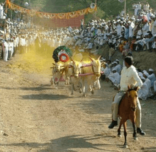
Ganesh utsav, Navratra utsav etc. are also celebrated with great enthusiasm.Janta Utsav is the famous festival of this area while other functions for yatra, wrestling, Tamasha and numerous religious programmes are held by various Mandals. Bullock cart races are an inseparable part of this taluka which is very prominent throughout Maharashtra.|
Hindu Temples and places of pilgrimage
.jpg)
- Bhimashankar
- Kulswami Khanderaiya,
- Loni,
- Dhamni,
- Bhargarvrao Valti,
- Narsingh Devalay,
- Ram Mandir (Ranjani),
- Velleshawar Mahadev Devsthan (Kurwandi),
- Aaradhya Devat Shree Ram Mandir Pimplegaon (Khadki),
- Sant Dnyaneshwar Temple (Chas),
- Tapneshwar Mahadev (Manchar),
- Gorakshnath Mandir (Avsari Phata),
- Bhairavnath Devsthan (Avsari),
- Harishchandra Mandir Ghodegaon,
- Ashtavinayak Ardhpeeth Vadgaon Kashimbeg,
- Rameshwar Mahadev Pandavkalin Babruvahanhi Mandir Manipur (Manchar),
- Mahadev Dongar (Kadewadi, Chas),
- Ghodnadi Source, (Ahupe),
- Ranjan khalge and film shooting spot (Chas),
- Shamadhar Parvat Eklahare,
- Kamaljadevi Mandir (Kalamb),
- Shree Vakeshwar Mandir (Peth),
- Sauranginath suvar parvat Bhavandi,
- Kamaljadevi shaktipeeth (Bhimashankar),
- Bhairavnath Mandir (Landewadi),
- Datta Mandir (Shinoli),
- Pach Pir (Vadgaon),
- Ram Mandir (Ambegaon Gavthan),
- Ahilyabai Holkar Fort (Vafgaon),
- Telecommunication Center, Narodi ( shiv mandir, vishanu temple), Holkar Wada and Temple,
- Jogeshwari Well commissioned by Ahilyabai Holkar (Khadki),
- Thapling(Shri Khanderaya Temple)(Nagapur).
- Shree kulswami Khanderaya Temple(peth, khandobamal) .
Places of Historical Importance and Recreation
- Dhimbhe Dam and Water power project,
- Peth Avasari Ghat. Huge walls and entry Gate of Holkars Period,
See also
- Talukas in Pune district
- 2014 Malin landslide, which occurred in the village of Malin in Ambegaon taluka
References
- ↑ "Talukas in Pune district". Archived from the original on 10 March 2010.
- ↑ AP (30 July 2014). "Rain-triggered landslide buries homes in remote Indian village, killing at least 17". US News & World Report. Retrieved 30 July 2014.
- ↑ Chakravartyet. Al, Sumitet. Al (2012). "Deforestation: Causes, Effects and Control Strategies" (PDF). Intech.
- ↑ "The real reason for Pune village landslide: Forest was cleared for a govt scheme". Firstpost. Retrieved 2016-03-01.
- ↑ Mazoomdaar, Jay (31 July 2014). "Is India's construction boom behind Pune village landslide?". BBC. BBC News. Retrieved 1 August 2014.
- ↑ "Indian media: Deforestation behind deadly Pune landslide". BBC. BBC News. 31 July 2014. Retrieved 1 August 2014.
- ↑ Deo, Sharmila. "The Environment Education Programme in Bhimashankar Wildlife Sanctuary". Kalpavriksh Environmental Action Group. Archived from the original on 2011-02-21. Retrieved 2011-02-06.
- ↑ Karnik, Kusum (2003-02-21). "Guardians of the Forest". aseanbiodiversity.info. Shaswat Trust. Retrieved 2011-02-06.
- ↑ Joshi, R., Regulatory Requirements for Starting a School in Poona.Centre for Civil Society, CCS RESEARCH INTERNSHIP PAPERS 2004
- ↑ Campbell, James (editor); Melsens, S; Mangaonkar - Vaiude, P; Bertels, Inge (Authors) (2017). Building Histories: the Proceedings of the Fourth Annual Construction History Society Conference. Cambridge UK: The Construction History Society. pp. 27–38. ISBN 978-0992875138. Retrieved 3 October 2017.