Amapala
| Amapala | |
|---|---|
| Municipality | |
 Cathedral of Amapala | |
 Amapala | |
| Coordinates: 13°17′32″N 87°39′14″W / 13.29222°N 87.65389°WCoordinates: 13°17′32″N 87°39′14″W / 13.29222°N 87.65389°W | |
| Country |
|
| Departament | Valle |
| Area | |
| • Land | 75.2 km2 (29.0 sq mi) |
| Population (2015) | |
| • Municipality | 12,743 |
| • Urban | 2,482 |
| Time zone | UTC−6 (Central America) |
Amapala is a municipality in the Honduran department of Valle.
It is formed by El Tigre Island and its satellite islets and rocks in the Gulf of Fonseca. It has an area of 75.2 km² and a population of 2,482 as of the census of 2001 (of which 4 people were living on Isla Comandante). Thanks to a natural deep channel, and despite lacking modern infrastructure, Amapala long served as the main Honduran port in the Pacific Ocean.
History
Amapala was founded in 1838, and its port was opened and declared free in 1868. During the 19th century it exported large quantities of gold, silver and other ores, although its progress was retarded by the delay in constructing a transcontinental railway from Puerto Cortés.[1] Beginning in the late 19th century, Amapala was gradually replaced in importance by the port of San Lorenzo on the mainland.
A description of the town in 1881 can be found in the book A Lady's Ride Across Spanish Honduras by Mary Lester (a.k.a. Mary Soltera). It was intended to be the capital of the Republic of Central America in the late 1890s.
Climate
This area typically has a pronounced dry season. According to the Köppen climate classification system, Amapala has a tropical savanna climate, abbreviated "Aw" on climate maps.[2]
| Climate data for Amapala | |||||||||||||
|---|---|---|---|---|---|---|---|---|---|---|---|---|---|
| Month | Jan | Feb | Mar | Apr | May | Jun | Jul | Aug | Sep | Oct | Nov | Dec | Year |
| Average high °C (°F) | 33 (92) |
33 (92) |
33 (92) |
34 (93) |
33 (91) |
32 (90) |
33 (91) |
33 (91) |
32 (89) |
32 (89) |
32 (90) |
33 (91) |
33 (91) |
| Average low °C (°F) | 27 (80) |
27 (80) |
27 (81) |
28 (83) |
27 (81) |
27 (80) |
27 (80) |
27 (81) |
26 (79) |
27 (80) |
27 (80) |
27 (81) |
27 (80) |
| Average precipitation days | 0 | 0 | 0 | 2 | 5 | 6 | 5 | 6 | 5 | 2 | 1 | 0 | 32 |
| Source: Weatherbase [3] | |||||||||||||
Economy
The community receives funds from former residents who have moved to other countries. As of 2013 most residents work as fishermen, while 300 have formal jobs.[4]
Gallery
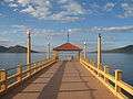 Boardwalk, Puerto de Amapala
 Building at La Plaza de Amapala
 Shore at Amapala
References
- ↑

- ↑ Climate Summary for Amapala, Honduras
- ↑ "Weatherbase.com". Weatherbase. 2013. Retrieved on October 18, 2013.
- ↑ Mackey, Danielle Marie (2014-12-15). ""I've Seen All Sorts of Horrific Things in My Time. But None as Detrimental to the Country as This."". The New Republic. Retrieved 2017-08-24.
Capital: Nacaome | ||
| Municipalities | 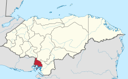 | |