Alligator Lake volcanic complex
| Alligator Lake volcanic complex | |
|---|---|
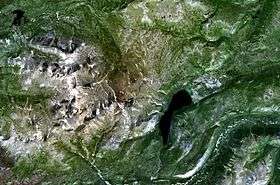 Aerial photo of the Alligator Lake volcanic complex | |
| Highest point | |
| Elevation | 2,217 m (7,274 ft) [1] |
| Listing | List of volcanoes in CanadaList of Northern Cordilleran volcanoes |
| Coordinates | 60°25′N 135°25′W / 60.417°N 135.417°W [1] |
| Geography | |
| Location | Yukon, Canada |
| Geology | |
| Age of rock | Holocene |
| Mountain type | Volcanic field |
| Volcanic arc/belt | Northern Cordilleran Volcanic Province |
| Last eruption | Unknown |
The Alligator Lake volcanic complex is a group of basaltic cinder cones and lava flows in south central Yukon. The upper part of the Alligator Lake volcanic complex consists of two well-preserved cinder cones capping a small shield volcano. They probably post-date the local Holocene glaciation. Lava flows from both cinder cones traveled to the north and were erupted simultaneously. Their compositions range from alkali olivine basalt to basanitic. Lava flows from the northeast cone are the largest extending 6 km (4 mi) from the cone and expanding to a width of 10 km (6 mi) at the terminus.[1]
The volcanic complex was named by the nearby Alligator Lake.
See also
References
- 1 2 3 "Alligator Lake". Global Volcanism Program. Smithsonian Institution. Retrieved 2006-10-14.
This article is issued from
Wikipedia.
The text is licensed under Creative Commons - Attribution - Sharealike.
Additional terms may apply for the media files.