Alinci (Prilep)
| Alinci Алинци | |
|---|---|
| Village | |
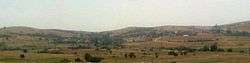 View of Alinci from Omec Hill | |
| Country | Republic of Macedonia |
| Municipality | Prilep |
| Elevation | 699 m (2,293 ft) |
| Population (2002) | |
| • Total | 238 |
| Time zone | UTC+1 (CET) |
| Area code(s) | +389-48 |
Alinci (Macedonian: Алинци) is a village in the Municipality of Prilep, Macedonia.
Geography
Alinci is located roughly 13 kilometres south-west from Prilep. [1]
History
Ancient History
Where Alinci is located today, during Roman times stood a now-excavated ancient Roman necropolis. [2]
19th Century
In the 19th century, Alinci was a Bulgarian village in the Prilep region of the Ottoman Empire.
20th Century
According to the statistics of Vasil Kanchov's book Macedonia. Ethnography And Statistics published in 1900, Alinci had a population of 102 people, all Bulgarian Christians.[3] In 1905, according to the French-published book written by Bulgarian publicist Dimitar Mishev La Macédoine et sa Population Chrétienne (English:Macedonia and it's Christian population), Alinci had a population of 120 people, all Bulgarians.[4]
At the outbreak of the Balkan Wars, a person from Alinci served in the Macedonian-Adrianopolitan Volunteer Corps.[5]
On 6 November 1914, following the Battle of Prilep, the Turkish V Corps of the Vardar Army retreated through Alinci to Bitola.[6]
Demographics
According to the 2002 census, there were 238 people living in the village, all Macedonians.[7]
Place of Worship
The Church of the Resurrection of Christ is located in Alinci.[8]
References
- ↑ https://www.google.com/maps/dir/Prilep+%D0%9F%D1%80%D0%B8%D0%BB%D0%B5%D0%BF/Alinci+%D0%90%D0%BB%D0%B8%D0%BD%D1%86%D0%B8/@41.2959886,21.4471455,11.92z/data=!4m14!4m13!1m5!1m1!1s0x1356ebf17ddb9787:0xe5931e06fb2150c1!2m2!1d21.5527922!2d41.3440827!1m5!1m1!1s0x1356e7f39dc77307:0xd5ecb388885d9751!2m2!1d21.4827377!2d41.2607207!5i1
- ↑ Template:Цитат уеб
- ↑ Васил Кънчов. „Македония. Етнография и статистика". София, 1900, стр.244.
- ↑ D.M.Brancoff. "La Macédoine et sa Population Chrétienne". Paris, 1905, р.148-149.
- ↑ „Македоно-одринското опълчение 1912-1913 г. Личен състав", Главно управление на архивите, 2006, стр.388 и 826.
- ↑ Войната между България и Турция през 1912-1913 год., Том VI, Министерство на войната, София 1935, стр. 201-203
- ↑ "Министерство за Локална Самоуправа. База на општински урбанистички планови". Archived from the original on 15 September 2008. Retrieved 17 August 2017.
- ↑ https://www.google.com/maps/place/Church+of+the+Resurrection+of+Christ/@41.2560721,21.4763762,15.25z/data=!4m8!1m2!2m1!1sChurch+of+the+Resurrection+of+Christ!3m4!1s0x0:0xa4140fe3e2794de1!8m2!3d41.2613721!4d21.4867258
Coordinates: 41°15′34″N 21°28′56″E / 41.25944°N 21.48222°E