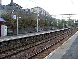
Alexandra Parade railway station
This station was once named Alexandra Park: for a guide to the various stations of that name see Alexandra Park railway station (disambiguation).
| Alexandra Parade | |
|---|---|
| Scottish Gaelic: Pairèad Alexandra[1] | |
 | |
| Location | |
| Place | Glasgow Cross |
| Local authority | Glasgow |
| Coordinates | 55°51′49″N 4°12′39″W / 55.8637°N 4.2107°WCoordinates: 55°51′49″N 4°12′39″W / 55.8637°N 4.2107°W |
| Grid reference | NS617655 |
| Operations | |
| Station code | AXP |
| Managed by | Abellio ScotRail |
| Number of platforms | 2 |
|
Live arrivals/departures, station information and onward connections from National Rail Enquiries | |
| Annual rail passenger usage* | |
| 2012/13 |
|
| 2013/14 |
|
| 2014/15 |
|
| 2015/16 |
|
| 2016/17 |
|
| History | |
| 1 July 1881 | Opened as Alexandra Park[2] |
| 1 January 1917 | Station closed[2] |
| 2 June 1919 | Station reopened[2] |
| 9 July 1923 | Station renamed Alexandra Parade[2] |
| National Rail – UK railway stations | |
| * Annual estimated passenger usage based on sales of tickets in stated financial year(s) which end or originate at Alexandra Parade from Office of Rail and Road statistics. Methodology may vary year on year. | |
|
| |
| Railways in Parkhead area | |||||||||||||||||||||||||||||||||||||||||||||||||||||||||||||||||||||||||||||||||||||||||||||||||||||||||||||||||||
|---|---|---|---|---|---|---|---|---|---|---|---|---|---|---|---|---|---|---|---|---|---|---|---|---|---|---|---|---|---|---|---|---|---|---|---|---|---|---|---|---|---|---|---|---|---|---|---|---|---|---|---|---|---|---|---|---|---|---|---|---|---|---|---|---|---|---|---|---|---|---|---|---|---|---|---|---|---|---|---|---|---|---|---|---|---|---|---|---|---|---|---|---|---|---|---|---|---|---|---|---|---|---|---|---|---|---|---|---|---|---|---|---|---|---|---|
| |||||||||||||||||||||||||||||||||||||||||||||||||||||||||||||||||||||||||||||||||||||||||||||||||||||||||||||||||||
|
Railways:
| |||||||||||||||||||||||||||||||||||||||||||||||||||||||||||||||||||||||||||||||||||||||||||||||||||||||||||||||||||
Alexandra Parade railway station is a railway station in Glasgow, Scotland. The station is 1¾ miles (3 km) east of Glasgow Queen Street on the North Clyde Line (Springburn branch). The station is managed by Abellio ScotRail.
It was built as part of the City of Glasgow Union Railway which provided a link across the Clyde (between the Glasgow and Paisley Joint Railway at Shields Junction and the Edinburgh and Glasgow Railway at Sighthill Junction).
Services
- 2tph to Dumbarton Central via Glasgow Queen St Low Level, Yoker and Dalmuir
- 2tph to Cumbernauld
On Sundays, an hourly Partick to Cumbernauld service each way operates between 9am and 8pm.[3]
| Preceding station | Following station | |||
|---|---|---|---|---|
| Barnhill | Abellio ScotRail North Clyde Line |
Duke Street | ||
| Historical railways | ||||
| Garngad Line open; Station closed |
City of Glasgow Union Railway G&SWR and NBR |
Duke Street Line and Station open | ||
References
- ↑ Brailsford 2017, Gaelic/English Station Index.
- 1 2 3 4 Butt (1995)
- ↑ Table 226 National Rail timetable, May 2016
Sources
- Brailsford, Martyn, ed. (December 2017) [1987]. Railway Track Diagrams 1: Scotland & Isle of Man (6th ed.). Frome: Trackmaps. ISBN 978-0-9549866-9-8.
- Butt, R. V. J. (1995). The Directory of Railway Stations: details every public and private passenger station, halt, platform and stopping place, past and present (1st ed.). Sparkford: Patrick Stephens Ltd. ISBN 978-1-85260-508-7. OCLC 60251199.
- Jowett, Alan (March 1989). Jowett's Railway Atlas of Great Britain and Ireland: From Pre-Grouping to the Present Day (1st ed.). Sparkford: Patrick Stephens Ltd. ISBN 978-1-85260-086-0. OCLC 22311137.
- Jowett, Alan (2000). Jowett's Nationalised Railway Atlas (1st ed.). Penryn, Cornwall: Atlantic Transport Publishers. ISBN 978-0-906899-99-1. OCLC 228266687.
This article is issued from
Wikipedia.
The text is licensed under Creative Commons - Attribution - Sharealike.
Additional terms may apply for the media files.