Alcove Springs
|
Alcove Springs | |
 | |
  | |
| Nearest city | Blue Rapids, Kansas |
|---|---|
| Coordinates | 39°44′57″N 96°40′33″W / 39.74917°N 96.67583°WCoordinates: 39°44′57″N 96°40′33″W / 39.74917°N 96.67583°W |
| Area | 714 acres (289 ha) |
| NRHP reference # | 72000513[1] |
| Added to NRHP | February 23, 1972 |
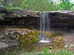
Alcove Springs was a popular stop along the Oregon Trail near Independence Crossing in Marshall County, Kansas. Travelers along the trail gave the springs its name. you can still find the words 'Alcove Springs' carved into the hard limestone cliff. <Legends of America>It is located about four miles north of Blue Rapids.
Across the road from the Alcove Springs park is another park commemorating the Oregon Trail and features history, wagon swales and a D.A.R. marker memorializing Sarah Keyes, a member of the Donner Party who died in 1846. The exact location of her burial is unknown.
Alcove Springs was listed on the National Register of Historic Places in 1972.[1][2]
References
- 1 2 National Park Service (2010-07-09). "National Register Information System". National Register of Historic Places. National Park Service.
- ↑ Richard Pankratz (March 8, 1971). "National Register of Historic Places Inventory/Nomination: Alcove Springs". National Park Service. Retrieved December 6, 2017. With three photos from 1971.
External links
- Alcove Spring & Waterfall - Kansas Travel
- Places to Visit—Alcove Spring - GeoKansas
This article is issued from
Wikipedia.
The text is licensed under Creative Commons - Attribution - Sharealike.
Additional terms may apply for the media files.