Alavaimalai
| Alavaimalai | |
|---|---|
|
அலவாய்மலை | |
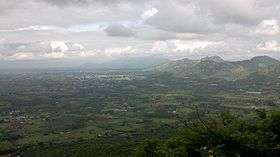 Aerial view of Vennandur block, view of Ponsorimalai and beyond that view of Kanjamalai from Alavaimalai | |
| Highest point | |
| Elevation | 900 m (3,000 ft) |
| Coordinates | 11°28′10.7″N 78°07′10.3″E / 11.469639°N 78.119528°ECoordinates: 11°28′10.7″N 78°07′10.3″E / 11.469639°N 78.119528°E |
| Dimensions | |
| Length | 6.437 km (4.000 mi) N–S |
| Width | 4.828 km (3.000 mi) E–W |
| Area | 31.08009 km2 (12.00009 sq mi) |
| Naming | |
| Translation | Half Way Hill(அலவாய்மலை) (Tamil) |
| Geography | |
| Location | Vennandur block, Athanur |
| Parent range | which is part of the Eastern Ghats |
| Biome | Forests |
| Climbing | |
| Easiest route | MDR-46-Namakkal, Steps to Temple from foot hill in Alavaipatti. |
Alavaimalai(Tamil: அலவாய்மலை,) [1] is a hill in Vennandur block, Namakkal district, Tamil Nadu state, India.
Mythology
The name Alavaimalai is derived from Tamil language. Alavaimalai: Arai-அரை+Vazhi-வழி+Malai-மலை. That is Arai-Half, Vazhi-Way, Malai-Hill. The Alavaimalai Subrayar Murugan Temple[2] is located half of the hill and face to weast side.
Geographic
Alavaimalai is part of eastern ghats. Vennandur is located west from Alavaimalai. Athanur is located north from Alavaimalai. Vaiyappamalai is located south from Alavaimalai. And Rasipuram is located east from Alavaimalai.
Places
- Forest Extension Center is located in Alavaimalai near District Major Road, Athanur.
- Alavaimalai Subrayar Murugan Temple in Alavaimalai.
- Sidhar Kovil in Alavaimalai near District Major Road
References
This article is issued from
Wikipedia.
The text is licensed under Creative Commons - Attribution - Sharealike.
Additional terms may apply for the media files.