Al Khuwayr
| Al Khuwayr الخوير | |
|---|---|
| Abandoned village | |
 | |
 Al Khuwayr Location in Qatar | |
| Coordinates: 26°4′29″N 51°5′1″E / 26.07472°N 51.08361°ECoordinates: 26°4′29″N 51°5′1″E / 26.07472°N 51.08361°E | |
| Country | Qatar |
| Municipality | Ash Shamal |
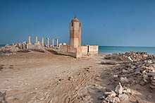
Al Khuwayr (Arabic: الخوير) is an abandoned village in Qatar, located in the municipality of Ash Shamal. It is a popular domestic tourist attraction due to its history and ruined structures.[1]
History
Al Khuwayr was previously known as Khor Hassan,[2] literally meaning 'beautiful inlet'.[3] In the late 18th century, noted pirate and tribal leader Rahmah ibn Jabir al-Jalahimah settled Al Khuwayr. It served as his base of operations against the Al Khalifa in Bahrain.[4] Rahmah's base in Al Khuwayr was surrounded by a protected bay which rendered the area a conceivably difficult target for his enemies. He resided in a fort with mud walls and there were only a few huts in the vicinity.[5]
J.G. Lorimer's Gazetteer of the Persian Gulf gives an account of Al Khuwayr in 1908:
A village on the west coast of the Qatar promontory about 10 miles from its northern extremity. It is frequently spoken of simply as "Khuwair" in contradistinction to "Khor" on the opposite side of the promontory. Khuwair possesses a tribal fort in a good state of repair and is inhabited by about 80 families of the Kibisah [Qubaisi] tribe, who live solely by pearl diving and fishing; they have 20 pearl boats [manned by 240 men], 5 fishing boats and 20 camels, but no other resources of any sort. Drinking water is fetched from Thaqab, about 3 miles to the south-east. A small islet off Khuwair Hassan is known as Jazirat-al-Khuwair.[6]
Al Khuwayr was among the villages occupied by Abdullah bin Jassim Al Thani's forces in July 1937 during his military expedition against the Naim tribe and its supporters, whom he considered to be defectors to Bahrain.[7]
Geography
To the immediate north of Al Khuwayr is an island called Al Khuwayr Island.[8]
Education
The settlement's first formal school was opened in 1957.[9]
Notable residents
- Qatari ibn al-Fuja'a, 7th century Arab poet and Khariji leader[10]
- Rahmah ibn Jabir al-Jalahimah, 18th–19th century pirate and transitory ruler of Qatar[4]
References
- ↑ Shereen D’Souza & Buthyna Al-Mohammad (27 August 2017). "We road trip along the Qatari coast to find all the best outdoor locations to check out this month". Time Out Doha. Retrieved 5 August 2018.
- ↑ "Ras 'Ushairiq / Ruwayda (Qatar): Coastal Heritage Revealed". University of Wales Trinity Saint David. Retrieved 9 June 2015.
- ↑ "The coming of Islam". Fanack Chronicle. Retrieved 14 August 2015.
- 1 2 McCoy, Lisa (2014). Qatar (Major Muslim Nations). Mason Crest. p. 51.
- ↑ "The Scourge of the Pirate Coast". Qatar Visitor. Archived from the original on 28 July 2015.
- ↑ "'Gazetteer of Arabia Vol. I' [788] (843/1050)". Qatar Digital Library. Retrieved 29 July 2015. This article incorporates text from this source, which is in the public domain.
- ↑ "'File 4/13 II Zubarah' [212r] (429/543)". Qatar Digital Library. Retrieved 6 July 2018.
- ↑ "GIS Portal". Ministry of Municipality and Environment. Retrieved 10 August 2017.
- ↑ Abdulla Juma Kobaisi (1979). "The Development of Education in Qatar, 1950–1970" (PDF). Durham University. p. 41–42. Retrieved 19 December 2015.
- ↑ al-Aqlām. 1. Wizārat al-Thaqāfah wa-al-Irshād.
وذكر في وفيات الاعيان لابن خنكان ابو نعامة قطري بن الفجاءة واسمه جعونة ين مازن بن يزيد اين زياد ين حبتر بن مالك ين عمرو رين تهيم بن مر التميمي الثسيباني ولد في الجنوب الشرقي من قرية الخوير شمال قطر في
Capital: Madinat ash Shamal | |
| Administrative zones | |
| Other settlements |
|