Airlie, Minnesota
| Airlie, Minnesota | |
|---|---|
| Unincorporated community | |
 Airlie, Minnesota  Airlie, Minnesota | |
| Coordinates: 44°01′12″N 96°26′17″W / 44.02000°N 96.43806°WCoordinates: 44°01′12″N 96°26′17″W / 44.02000°N 96.43806°W | |
| Country | United States |
| State | Minnesota |
| County | Pipestone |
| Elevation | 1,660 ft (510 m) |
| Time zone | UTC-6 (Central (CST)) |
| • Summer (DST) | UTC-5 (CDT) |
| Area code(s) | 507 |
| GNIS feature ID | 654562[1] |
Airlie is an unincorporated community in Sweet Township, Pipestone County, Minnesota, United States. It is located near Minnesota State Highway 30 between Pipestone, Minnesota and Egan, South Dakota, one mile east of the Minnesota – South Dakota state line.[1]
History
Airlie was platted in 1879, and named for the Earl of Airlie.[2] A post office was established at Airlie in 1882, and remained in operation until 1934.[3]
References
- 1 2 "Airlie". Geographic Names Information System. United States Geological Survey.
- ↑ Upham, Warren (1920). Minnesota Geographic Names: Their Origin and Historic Significance. Minnesota Historical Society. p. 417.
- ↑ "Pipestone County". Jim Forte Postal History. Retrieved 31 July 2015.
External links
Municipalities and communities of Pipestone County, Minnesota, United States | ||
|---|---|---|
| Cities | 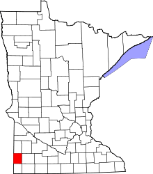 | |
| Townships | ||
| Unincorporated communities | ||
| Footnotes | ‡This populated place also has portions in an adjacent county or counties | |
This article is issued from
Wikipedia.
The text is licensed under Creative Commons - Attribution - Sharealike.
Additional terms may apply for the media files.