Ahuachapán Department
| Ahuachapán | |||
|---|---|---|---|
| Department | |||
 | |||
| |||
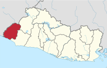 Location within El Salvador | |||
| Coordinates: 13°52′01″N 89°53′31″W / 13.867°N 89.892°WCoordinates: 13°52′01″N 89°53′31″W / 13.867°N 89.892°W | |||
| Country |
| ||
| Created | 1869 | ||
| Seat | Ahuachapán | ||
| Area | |||
| • Total | 1,239.6 km2 (478.6 sq mi) | ||
| Area rank | Ranked 8th | ||
| Population | |||
| • Total | 333,406 | ||
| • Rank | Ranked 7th | ||
| • Density | 270/km2 (700/sq mi) | ||
| Time zone | UTC−6 (CST) | ||
| ISO 3166 code | SV-AH | ||


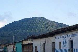
Ahuachapán is a department of El Salvador in the west of the country. The capital is Ahuachapán. In the South it has the Apenca-Ilamatepec Range and the Cerro Grande de Apaneca (Apaneca Grand Hill). Its extension is 1,240 km² and has more than 333,000 people living in the department.
Municipalities
This article is issued from
Wikipedia.
The text is licensed under Creative Commons - Attribution - Sharealike.
Additional terms may apply for the media files.