Aguilar de Codés
| Aguilar de Codés Aguilar Kodes (Basque) | ||
|---|---|---|
| Municipality | ||
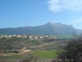 View of Aguilar de Codés with the Sierra de Codés in the background. | ||
| ||
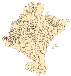 Location in Navarre | ||
| Coordinates: 42°36′46″N 2°23′21″W / 42.61278°N 2.38917°W | ||
| Country | Spain | |
| Autonomous Community | Navarre | |
| Merindad | Estella Occidental | |
| Founded | 1219 by Sancho VII of Navarre | |
| Government | ||
| • Mayoress | Amparo Labeaga Díaz de Cerio (indep.) | |
| Area | ||
| • Total | 18.16 km2 (7.01 sq mi) | |
| Elevation | 731 m (2,398 ft) | |
| Population (2008) | ||
| • Total | 4,878 | |
| • Density | 270/km2 (700/sq mi) | |
| Time zone | UTC+1 (CET) | |
| • Summer (DST) | UTC+2 (CEST) | |
| Postal code | 31228 | |
| Official language(s) | Basque, Spanish | |

Aguilar de Codés is a town and municipality located in the province and autonomous community of Navarra, northern Spain. The name "Codés" comes from neighboring Sierra de Codés, that closes the northern end of the valley where Aguilar lies.[1]
References
External links

- Aguillar de Codés in the Bernardo Estornés Lasa - Auñamendi Encyclopedia (Euskomedia fondoak) (in Spanish)
This article is issued from
Wikipedia.
The text is licensed under Creative Commons - Attribution - Sharealike.
Additional terms may apply for the media files.