Agloe, New York
| Agloe | |
|---|---|
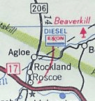 Fictional Agloe, New York, a copyright trap, shown on a real map of New York published by Exxon in 1998. | |
| A General Drafting map location | |
| Created by | Otto G. Lindberg and Ernest Alpers |
| Genre | Map |
| Type | Hamlet, copyright trap |
| Notable locations | Agloe General Store (formerly) |
| First appearance | c. 1930 |
| State | New York |
| County | Delaware County, New York |
| Town | Colchester, New York |
| ZIP code | 12776[1] |
Agloe is a fictional hamlet in Colchester, Delaware County, New York, that became an actual landmark after mapmakers made up the community as a "copyright trap", similar to a trap street. Agloe was put onto the map in order to catch plagiarism due to Agloe being only on their map and not on any others. Soon, using fictional "copyright traps" became a typical strategy in mapmaker design to thwart plagiarism. Agloe was known as a "paper town" due to this.
History
In the 1930s, General Drafting founder Otto G. Lindberg and an assistant, Ernest Alpers, assigned an anagram of their initials to a dirt-road intersection in the Catskill Mountains: NY 206 and Morton Hill Road, north of Roscoe, New York.[2] The town was designed as a "copyright trap" to enable the publishers to detect others copying their maps.
In the 1950s, a general store was built at the intersection on the map, and was given the name Agloe General Store because the name was on the Esso maps.[3] Later, Agloe appeared on a Rand McNally map after the mapmaker got the name of the "hamlet" from the Delaware County administration. When Esso threatened to sue Rand McNally for the assumed copyright infringement which the "trap" had revealed, the latter pointed out that the place had now become real and therefore no infringement could be established.
Eventually the store went out of business; Agloe continued to appear on maps as recently as the 1990s, but has now been deleted. It briefly appeared on Google Maps.[4] The United States Geological Survey added "Agloe (Not Official)" to the Geographic Names Information System database on February 25, 2014.[5]
In popular culture
Agloe is featured in the novel Paper Towns by John Green and its film adaptation. During the film and in the novel, one of the main characters, Margo Roth Spiegelman, runs away from home, leaving personal clues to her friend and neighbor Quentin Jacobsen to come and find her. He then discovers she is hiding in one of the US' most famous "Paper Towns", Agloe, NY. The book's name is based on the several paper towns that Margo discovers and encounters while running away.
See also
References
- ↑ "US Postal Code Boundaries". Google. Google, Inc. 3 February 2014. Retrieved 15 December 2015.
- ↑ Lackie, John (25 November 2006). "Copyright traps". New Scientist (The Word ed.). 192 (2574): 62. doi:10.1016/S0262-4079(06)60797-5. Archived from the original on 13 October 2008. Retrieved 1 September 2008.
- ↑ Byrne, Ian (19 March 2006). "Errors on road maps(2)". Petrol Maps. ianbyrne.free-online.co.uk. Archived from the original on 2008-09-28. Retrieved 1 September 2008.
- ↑ Krulwich, Robert (18 March 2014). "An Imaginary Town Becomes Real, Then Not. True Story". Retrieved 3 June 2014.
- ↑ "Agloe (Not Official)". Geographic Names Information System. United States Geological Survey. 25 February 2014. Retrieved 15 December 2015.
Coordinates: 41°57′57″N 74°54′22″W / 41.96583°N 74.90611°W