River Dwyryd
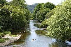
The River Dwyryd (Welsh: Afon Dwyryd, meaning a river of two fords) is a river in Gwynedd, Wales which flows principally westwards; draining to the sea into Tremadog Bay, south of Porthmadog.
Geography
The Dwyryd rises in the hills to the north of Ffestiniog. At its most northern extent, water draining from Moelwyn Mawr drains into the Tanygrisiau Reservoir, the outflow of which forms the source of the Afon Goedol. This is joined by the River Bowydd at grid reference: SH695438. Below Rhyd y Sarn, the river is joined by the Afon Cynfal which flows from the east down a deep wooded gorge which includes the spectacular Rhaeadr Cynfal (Cynfal waterfall) south of Ffestiniog. The main river then flows through a wide valley formed by glaciation, with a broad flat base formed from glacial moraines and riverine gravel deposits. The valley, the Vale of Ffestiniog, has much agriculture but is subject to routine winter flooding.
The Afon Tafarn-helyg has its confluence about one mile further downstream. This tributary rises south of Gellilydan and just north of the reservoir of Llyn Trawsfynydd but does not receive any water from the reservoir.
There are a number of small lakes and reservoirs in the woodlands north of Plas Tan y Bwlch which also drain south into the river. These lakes include Llyn y Garnedd, Llyn Hafod y Llyn and Llyn Mair.
At Maentwrog the Dwyryd becomes a long tidal estuary.
Llyn Trawsfynydd, a large reservoir close to the A470, is the only inland water in the UK that has been used as a source of cooling water for a nuclear power station. The spill flow from the reservoir, the Afon Prysor, flows down the steeply wooded valley of Ceunant Llennyrch before joining the tidal Dwyryd. Most of the flow from the reservoir is channelled through the hydro-electric power station close to Maentwrog; the flow then re-joins the Prysor just before the confluence.
The Dwyryd then flows under the road and railway line at Pont Briwet. South of Portmeirion the river is joined by the Afon y Glyn which drains the south west catchment from Llyn Tecwyn Uchaf and Llyn Tecwyn Isaf. The confluence is adjacent to Glastraeth (green beach) - a large extent of salt marsh.
The estuary of the Dwyryd is long and sandy and meets the River Glaslyn close to the low water mark.
The whole of the river drains off igneous and ancient rocks of the Cambrian and Ordovician which are all base-poor. Much of the catchment has also been used for commercial forestry during the last hundred years. As a consequence, many of the tributaries are highly acidic as a result of atmospheric acidification. This has constrained the quality of the fishery and the bio-diversity in many tributaries. Some of these problems have been exacerbated by past industrial actions including metal mining, slate mining, animal skin processing and the use by the army of a gunnery range with large amounts of implaced metal cartridge shells.
River traffic
At no point is the river deep enough to accommodate sea-going ships, but in the second half of the 18th century a number of quays were constructed west of Maentwrog from which small vessels took cargoes of timber and, increasingly, slate to be transferred to sea-going ships[1] in deeper water south west of what would become Porthmadog, transferring to Porthmadog itself when its harbour was opened in 1824. The river was and remains so shallow that viable cargoes could only be carried at spring tides. Some of the quays remain to this day,[2] used by anglers. The opening of the Ffestiniog Railway in 1836 dealt a mortal blow to the Dwyryd traffic, which ended completely by 1860.[3]
References
- ↑ Slate traffic on the Dwyryd Penmorfa
- ↑ Senior 2013, p. 26.
- ↑ Lewis 1989, p. 9.
Sources
- Lewis, M.J.T. (1989). Sails on the Dwyryd, The River Transport of Ffestiniog Slate. Plas Tan y Bwlch: Snowdonia National Park Study Centre. ISBN 978-1-84527-206-7.
- Senior, Michael (2013). The Vale of Ffestiniog and its Hinterland. Llanrwst: Gwasg Carreg Gwalch. ISBN 978-0-8452-7225-1.
Further material
- Cook, W.; Rees, E. I. S. (1978). Survey of macroinvertebrate populations in the Glaslyn/Dwyryd estuary. Bangor: University College of North Wales. OCLC 26878862.
- McElvogue, D. M. (2003). "Cwch Talsarnau: a boat from the Afon Dwyryd". Maritime Wales. Caernarfon: Gwynedd Archives. 24: 41–49. ISSN 0308-2334.
- Mahamod, Yusuff (1989). Sedimentary processes in the Dwyryd estuary. Bangor: University College of North Wales. OCLC 59073406.
- Parr, W.; Wheeler, M.; Codling, I. (1999). Nutrient status of the Glaslyn/Dwyryd, Mawddach and Dyfi estuaries : its context and ecological importance. Bangor: Countryside Council for Wales. OCLC 41159259.
- Richards, Alun John; Napier, Jean (2008). Two Snowdonia rivers : Glaslyn & Dwyryd. Llanrwst: Gwasg Carreg Gwalch. ISBN 978-0-9512373-3-5.
- Welsh Region, National Rivers Authority (1995). Glaslyn/Dwyrd/Artro catchment management plan : Consultation report : May 1995. Cardiff: National Rivers Authority. OCLC 35784878.
External links
- The river on navigable OS maps with satellite overlays National Library of Scotland
| Wikimedia Commons has media related to Afon Dwyryd. |
Coordinates: 52°58′32″N 3°56′42″W / 52.97562°N 3.94496°W
