Aetna Township, Barber County, Kansas
| Aetna Township | |
|---|---|
| Township | |
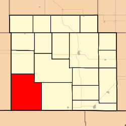 Location in Barber County | |
| Coordinates: 37°04′28″N 098°56′22″W / 37.07444°N 98.93944°WCoordinates: 37°04′28″N 098°56′22″W / 37.07444°N 98.93944°W | |
| Country | United States |
| State | Kansas |
| County | Barber |
| Area | |
| • Total | 123.04 sq mi (318.66 km2) |
| • Land | 122.88 sq mi (318.25 km2) |
| • Water | 0.16 sq mi (0.42 km2) 0.13% |
| Elevation | 1,604 ft (489 m) |
| Population (2000) | |
| • Total | 3 |
| • Density | 0/sq mi (0/km2) |
| GNIS feature ID | 0485522 |
Aetna Township is a township in Barber County, Kansas, USA. At the 2000 census, its population was 3.
Geography
Aetna Township covers an area of 123.04 square miles (318.7 km2) and contains no incorporated settlements. According to the USGS, it contains one cemetery, Aetna.
The streams of Ash Creek, Big Sandy Creek, Deadman Creek, Dry Creek, East Dry Creek, Mule Creek and West Dry Creek run through this township.
References
External links
Municipalities and communities of Barber County, Kansas, United States | ||
|---|---|---|
| Cities | 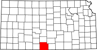 | |
| Unincorporated communities | ||
| Townships | ||
This article is issued from
Wikipedia.
The text is licensed under Creative Commons - Attribution - Sharealike.
Additional terms may apply for the media files.