Adolphe Bridge
| Adolphe Bridge | |
|---|---|
 | |
| Coordinates | 49°36′30″N 6°07′37″E / 49.6083°N 6.1270°ECoordinates: 49°36′30″N 6°07′37″E / 49.6083°N 6.1270°E |
| Carries | Road traffic and pedestrians |
| Crosses | Pétrusse river |
| Locale | Luxembourg City |
| Official name | Pont Adolphe |
| Maintained by | Administration des ponts et chaussées |
| Characteristics | |
| Design | Open spandrel Arch |
| Total length | 153 metres (502 ft) |
| Width | 17.20 metres (56.4 ft) |
| Longest span | 84.65 metres (277.7 ft) |
| Clearance below | 42 metres (138 ft) |
| History | |
| Construction start | 14 July 1900 |
| Construction end | 24 July 1903 |
| Opened | 24 July 1903 |
The Adolphe Bridge (Luxembourgish: Adolphe-Bréck, French: Pont Adolphe, German: Adolphe-Brücke) is an arch bridge in Luxembourg City, in southern Luxembourg. The bridge takes road traffic across the Pétrusse, connecting Boulevard Royal, in Ville Haute, to Avenue de la Liberté, in Gare. At 153 meters long, it carries four lanes of road traffic, a bus lane to Ville Haute, and has two footpaths for pedestrians.[1]
The Adolphe Bridge has become an unofficial national symbol of sorts, representing Luxembourg's independence, and has become one of Luxembourg City's main tourist attractions. The bridge was designed by Paul Séjourné, a Frenchman, and Albert Rodange, a Luxembourger, and was built between 1900 and 1903. Its design was copied in the construction of Walnut Lane Bridge in Philadelphia, the United States.[2]
The bridge was named after Grand Duke Adolphe, who reigned Luxembourg from 1890 until 1905, and was the first monarch to hold the title not in personal union with another. Although it is now over 100 years old, it is also known as the New Bridge (Luxembourgish: Nei Bréck, French: Nouveau pont, German: Neue Brücke) by people from Luxembourg City. The 'old bridge' in this comparison is the Passerelle, which was built between 1859 and 1861.
History
Beginnings
With the demolition of the city's famous fortification, under the 1867 Treaty of London, and the decline of its strategic importance, Luxembourg City reverted to the normality enjoyed by other cities. The city's built-up area spread southwards from Haute Ville, over the Pétrusse, where Luxembourg City's railway station was already located. However, the only existing link to the south bank of the Pétrusse was the old viaduct, which (at 5.50 m wide) was too narrow to accommodate all the traffic that would be expected between two halves of the city.[1]
In 1896, the government hired Albert Rodange to draw up plans for a new bridge. Rodange identified the future bridge's position, connecting with the main axis of Boulevard Royal, and drew up initial plans for a large stone viaduct. However, as Rodange lacked experience in bridge building, the government invited a foreigner with specific expertise in the field to help design the bridge. Paul Séjourné, a Frenchman with years of experience designing similar viaducts in southern France, was chosen.[1]
Design

Although Séjourné concurred with Rodange's site and basic design, he made many major modifications. Instead of several medium-sized arches, Séjourné sought to build the bridge around a large central arch, flanked by smaller arches. The plan, which was adopted, called for:
- Twin parallel 84.65 m arches in the centre, surmounted by eight smaller arches of 5.40 m each.
- Two arches of 21.60 m flanking the central arch.
- Two further arches of 6.00 m outside the medium-sized arches.[1]
In total, the bridge would have a length of 153 m. The plans were audacious for that day and age; at 84.65 m, the central span was to be the largest stone arch in existence.[1] The roadway was constructed of reinforced concrete, a material that had only recently come into use, the weight of which was carried on the columns of the smaller arches, thereby saving the heavy infilling used in a conventional arched bridge.[3] The arches and columns were constructed from sandstone, quarried locally at Ernzen, Dillingen, Gilsdorf, and Verlorenkost.[1] This design was later replicated by Séjourné in a bridge over the River Garonne at Toulon and was copied in concrete for the Walnut Lane Bridge in Philadelphia.[3]
Construction
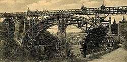
The foundation stone of the bridge was laid on the 14 July 1900, and it was inaugurated just over three years later, on 24 July 1903.[1] Originally, the bridge carried both road and rail traffic; two rail/tram tracks over the bridge formed part of the railway route from Luxembourg City to Echternach, which was opened on 20 April 1904.[4]
Renovation

.jpg)
The Adolphe Bridge has been renovated four times in its century of operation. Minor changes were made in 1961 and 1976, including the removal of rail lines following the end of the first generation of trams in Luxembourg. In 1990, the Luxembourgish government launched an investigation into the state of the bridge and found that it showed signs of extensive damage, to both the stonework and steel. Between September 2003 and August 2004, the central arches were strengthened by the addition of 258 prestressed steel bars, with a total force of 25,600 tonnes (251 MN).[1]
In concordance with the reintroduction of trams in Luxembourg, major redesign and renovation work occurred between 2014 and 2017, with a temporary bridge constructed parallel operating in the interim. The Adolphe Bridge was widened and reinforced to accommodate the new tramlines. Additionally, a new cycle and pedestrian path was suspended beneath the existing bridge to allow for increased traffic.
See also
References
- 1 2 3 4 5 6 7 8 "Le Pont Adolphe à Luxembourg" (PDF) (in French). gouvernement.lu. 2005-08-04. Retrieved 2006-08-03.
- ↑ "Walnut Lane Bridge". Structurae. Retrieved 2006-08-03.
- 1 2 Whitney, Charles S (2003), Bridges of the World: Their Design and Construction, Dover Publications, ISBN 978-0486429953 (p. 191)
- ↑ "Ligne Luxembourg - Echternach" (in French). rail.lu. Archived from the original on 15 August 2006. Retrieved 2006-08-03.
External links
| Wikimedia Commons has media related to Adolphe Bridge. |