Administrative division of Polish–Lithuanian territories after Partitions
| Territories of the Polish-Lithuanian Commonwealth during Partitions | |
|---|---|
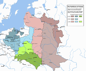 The three Partitions of Poland 1772–1795 | |
| End of the Commonwealth | |
 Disappearance of Poland from the map of Europe | |
| Territorial losses | |
| Total losses | 741,000 km2 |
| To Prussia | 149,000 km² with 2.6 million people |
| To Russia | 462,000 km² with 3.5 million people |
| To Austria | 130,000 km² with 3.85 million people |
The three consecutive partitions of Poland carried out in the late 18th century by the Austrian, Prussian and the Russian empires, between 1772 and 1795, resulted in the complete disappearance of sovereign Poland from the map of Europe until the end of World War One in 1918. The partitioning powers introduced new administrative divisions of the Polish–Lithuanian territories after Partitions. The new toponyms created in place of the former Polish-Lithuanian Commonwealth were further complicated by the changes within those empires themselves as well as periodic establishment of some form of the quasi-Polish province led by a foreign head of state.
The below divisions do not cover the administrative divisions of the two vassal states of the 19th century which included the administrative division of Duchy of Warsaw (1807–1815) and administrative division of Congress Poland (1815–1918). For the administrative division of the Polish-Lithuanian Commonwealth before its final third partition, see administrative division of Polish-Lithuanian Commonwealth. For administrative divisions of the states that partitioned Poland, covering their entire administrative division, see Provinces of Prussia and the History of the administrative division of Russia.
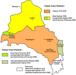
Austrian Partition
The Austrian Empire, known from second half of the 19th century as the Austro-Hungarian Empire, annexed Polish territories in the First (1772) and the Third Partition (1795) of Poland.[1] Austria divided the former territories of the Commonwealth it obtained into:
- Kingdom of Galicia and Lodomeria - from 1772 to 1918.
- New Galicia - from 1795 to 1809
- Free City of Kraków - from 1815 to 1846, later the Grand Duchy of Cracow
Two important and major cities of the Austrian partition were Kraków (Cracow) and Lwów (Lviv).
In the First Partition, Austria had received the largest share of the Polish population, and second largest land share (83,000 km² and over 2.65 million people). Austria had not participated in the Second partition. In the Third Partition, Austria annexed 47,000 km² of territories with 1.2 million people. Overall, Austria had gained about 18 percent of the former Commonwealth territory (130,000 km²) and about 32 percent of the population (3.85 million people).[1] From the geographical perspective, much of the Austrian partition corresponded to the Galicia region.
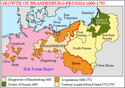
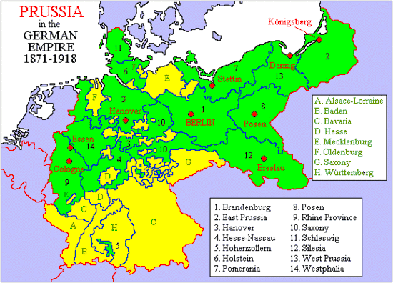
Prussian Partition
The Kingdom of Prussia (known from second half of the 19th century as German Empire) acquired Polish territories in all three partitions,[1] and divided the former territories of the Commonwealth it obtained into the following.[2]
- Netze District - from 1772 to 1793
- New Silesia - from 1795 to 1807
- New East Prussia - from 1795 to 1807
- South Prussia - from 1793 to 1806
- East Prussia - from 1773–1829
- West Prussia - from 1773–1824.[2]
In the First Partition, Prussia has received 36,000 km² and about 0.6 million people. In the second partition, Prussia had received 58,000 km² and about 1 million people. In the third, similar to the second, Prussia gained 55,000 km² and 1 million people. Overall, Prussia had gained about 20 percent of the former Commonwealth territory (149 000 km²) and about 23 percent of the population (2.6 million people).[1] From the geographical perspective, much of the territories annexed by Prussia formed the province of Greater Poland (Wielkopolska).
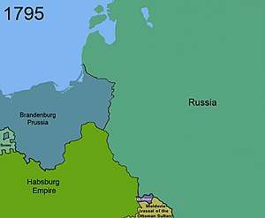
Russian Partition
The Russian Empire which acquired the territories of the Kingdom of Poland, the Grand Duchy of Lithuania and the Duchy of Courland and Semigallia in all three Partitions,[1] divided the former territories of the Commonwealth by either creating or enlarging the following guberniyas.[2]
- Belarus Governorate (1802)
- Bratslav Governorate
- Chernigov Governorate
- Kiev Governorate (1708)
- Lithuania Governorate (1795), later split into Lithuania-Grodno Governorate and Lithuania-Vilna Governorate, the last one later split into Vilna and Kovno Governorates
- Minsk Governorate (1793)
- Mogilev Governorate (1772)
- Podolia Governorate (1773)
- Polotsk Governorate
- Pskov Governorate
- Slonim Governorate (1795) (several months after creation connected to Lithuania Governorate in and split off from it in 1801 as Lithuania-Grodno Governorate)
- Volhynia Governorate (1793)[2]
After the Congress of Vienna in 1815, the Russian Empire created a separate entity called Congress Poland out of some of the above governorates. See administrative division of Congress Poland for details. Territories in the Russian partition which were not incorporated into Congress Poland were known as the Western Krai (combination of Northwestern and Southwestern Krais), and in Poland as the taken lands (Polish: ziemie zabrane).
The Western Krai comprised the following lands of the Commonwealth:
- from the first partition of Poland (1772): Polish Inflants (Latgale), the northern part of the Polotsk Voivodeship, the entire Mstsislaw Voivodeship and Vitebsk Voivodeships, and the southeastern part of the Minsk Voivodeship (about 92,000 km²)
- from the second partition of Poland (1793): the remaining part of the Minsk Voivodeship, the entire Kiev Voivodeship, Bracław Voivodeship and Vilnius Voivodeships, parts of Podole Voivodeship and eastern parts of the Wołyń Voivodeship and Brest Litovsk Voivodeships (about 250,000 km²)
- from the third partition of Poland (1795): all the territories east of the Bug River(about 120,000. km²) and after 1807 the Belostok Oblast)
It consisted of 9 guberniyas: six Belarusian and Lithuanian ones that constituted the Northwestern Krai (Vilna Governorate, Kovno Governorate, Grodno Governorate, Minsk Governorate, Mogilev Governorate and Vitebsk Governorate) and three Ukrainian ones that constituted the Southwestern Krai (Volhynia Governorate, Podolia Governorate and Kiev Governorate).
The Duchy of Courland and Semigallia was transformed into Courland Governorate (Government of Courland) and grouped with the Baltic governorates also known as Governments of Ostsee.
In the first partition, Russia gained 92,000 km² and 1.3 million people. In the second, 250,000 km² and 1 million people. In the third, 120,000 km² and 1.2 million people. Overall, Russia had gained about 62 percent of the former Commonwealth territory (462,000 km²) and about 45 percent of the population (3.5 million people).[1]
During World War I (1914–1918), much of the territories became occupied by the Central Powers (primarily, German Empire) and became administered by the Ober Ost.
References
- 1 2 3 4 5 6 Wandycz, Piotr Stefan (2001). The Price of Freedom: A History of East Central Europe from the Middle Ages to the Present. Routledge (UK). pp. 120–136. ISBN 0-415-25491-4 – via Google Print.
- 1 2 3 4 Dolan, Allison; Family Tree Magazine Editors (2015). The Family Tree Historical Maps Book - Europe: A Country-by-Country Atlas of European History, 1700s-1900s. Family Tree Books. p. 283. ISBN 1440342067.