Ad-Dawhah (municipality)
| Ad-Dawhah الدوحة ad-Dawḥa | |
|---|---|
| Municipality | |
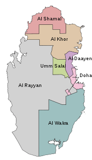
 Location of the municipality of Ad-Dawha within Qatar | |
| Coordinates: 25°17′12″N 51°32′0″E / 25.28667°N 51.53333°ECoordinates: 25°17′12″N 51°32′0″E / 25.28667°N 51.53333°E | |
| Country |
|
| Area | |
| • Total | 234 km2 (90 sq mi) |
| Population (2015)[1] | 956,457 |
| Time zone | UTC+3 (AST) |
Ad-Dawhah (Arabic: الدوحة, ad-Dawḥa or ad-Dōḥa, [addawħa]) is the one of the 8 municipalities of Qatar. It is the most populous municipality with a population of 956,457,[1] and its capital city is Doha.
Etymology
According to the Ministry of Municipality and Environment, the name "Doha" originated from the Arabic term "dohat", which means "roundness". This was name is derived from the rounded bays surrounding the area's coastline.[2]
Administration
.jpg)
According to the Ministry of Municipality and Urban Planning,[3] the Municipality of Qatar became the first municipality to be established in 1963. Later that year, the name was changed to Municipality of Ad Dawhah. The country has been divided into seven municipalities since 2006.[4] Doha is the most populated municipality among them with a population of 956,457 as of 2015.[1]
Municipal headquarters were shifted from the Al Sadd area to Ras Abu Aboud in 2017.[5]
Neighborhoods
Geography
Doha municipality is in the central east region of Qatar; it is bordered by Al Wakrah municipality to the south, Al Rayyan municipality to the west, Al Daayen municipality to the north and Umm Salal municipality to the northwest.[2]
Comprising the majority of Qatar's residential, financial and administrative centers, the Doha Metropolitan area hosts over 80% of the country's inhabitants. The core of Doha, which is the eastern-most area of the municipality, is the administrative and financial hub of the country and the municipality, with districts such as Al Dafna and West Bay being located here. Moreover, this area also accommodates critical infrastructure such as Hamad Medical City and Hamad International Airport.[6]
Other areas of importance include the Industrial Area, an exclave in Al Rayyan municipality, as well as the Wholesale Market Area, which encompasses the western portion of the municipality and which unofficially includes areas of Al Rayyan.[6]
In the northern region of Doha, developments such as the Katara Cultural Village and The Pearl-Qatar, which is projected to house as many as 45,000 residents, can be found. The northern part of the West Bay financial district is also located here. Towards the center of the municipality is the Amiri Diwan, Souq Waqif, the Doha Corniche and the historic quarters.
Most of the low-to-medium density housing projects are found in the western sector, near the Wholesale Market Area.[6] Residential areas in western Doha include Al Sadd, Abu Hamour and Al Gharafa, of which the latter two are geographically located in Al Rayyan but which constitute a part of Metropolitan Doha.[7]
Infrastructure
Education
As the most populous municipality, Doha contains the highest density of schools in the country. Most of the municipality's schools are near the core of Doha, i.e. the central eastern portion. There is a reported shortage of schools in the Al Sadd district, as well as the northernmost and southernmost sectors.[8]
Healthcare
A major healthcare project known as Hamad Medical City was launched in 2003 near the Rumeilah district. Three hospitals and a research center were planned to be hosted within this 227,000 square meter complex at a cost of over QR 2.1 billion.[9] In December 2017, Hamad Medical City was officially opened in a ceremony attended by the Emir of Qatar, Tamim bin Hamad Al Thani.[10]
Transport
The under-construction Doha Metro will connect the core of Doha with its metropolitan hubs. At the center of the Doha Metro is Msheireb Station, where it is planned for three alignments and a bus rapid transit system to connect.[11]
References
- 1 2 3 "2015 Population census" (PDF). Ministry of Development Planning and Statistics. April 2015. Retrieved 29 May 2018.
- 1 2 "District map". The Centre for Geographic Information Systems of Qatar. Retrieved 29 May 2018.
- ↑ "وزارة البلدية والتخطيط العمراني". Baladiya.gov.qa. 2013-01-04. Retrieved 2013-03-26.
- ↑ "Qatar Municipalities". Qatar Ministry of Municipality and Urban Planning. Archived from the original on 2011-12-22. Retrieved 2017-01-29.
- ↑ "بلدية الدوحة تنتقل إلى مقر جديد بمنطقة رأس أبو عبود" (in Arabic). Al Arab. 22 October 2017. Retrieved 31 May 2018.
- 1 2 3 "Doha Municipality: Vision and Development Strategy" (PDF). Ministry of Municipality and Environment. 1 June 2014. p. 4. Retrieved 29 May 2018.
- ↑ "Doha Municipality: Vision and Development Strategy" (PDF). Ministry of Municipality and Environment. 1 June 2014. p. 18. Retrieved 29 May 2018.
- ↑ "Doha Municipality: Vision and Development Strategy" (PDF). Ministry of Municipality and Environment. 1 June 2014. p. 26. Retrieved 29 May 2018.
- ↑ "Hamad Medical City to open doors to public by end of 2014". justhere.qa. 25 December 2013. Retrieved 29 May 2018.
- ↑ "Emir officially opens HMC's new Medical City hospitals". Gulf Times. 17 December 2017. Retrieved 29 May 2018.
- ↑ "Doha Municipality: Vision and Development Strategy" (PDF). Ministry of Municipality and Environment. 1 June 2014. p. 34. Retrieved 29 May 2018.
| ||