West Aceh Regency
| West Aceh Regency اچيه بارت | ||
|---|---|---|
| Regency | ||
 | ||
| ||
 Location within Aceh | ||
| Coordinates: 4°27′N 96°11′E / 4.450°N 96.183°E | ||
| Country | Indonesia | |
| Region | Sumatra | |
| Province | Aceh | |
| Regency | 1956 | |
| Capital | Meulaboh | |
| Government | ||
| • Regent | Ramli | |
| • Vice Regent | Banta Puteh Syam | |
| Area | ||
| • Total | 2,927.95 km2 (1,130.49 sq mi) | |
| Population (2014) | ||
| • Total | 182,721 | |
| • Density | 62/km2 (160/sq mi) | |
| Time zone | UTC+7 (IWST) | |
| Area code | (+62) 655 | |
| Website |
www | |

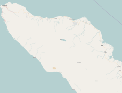


West Aceh Regency is a regency (Indonesian: kabupaten) in the Aceh special region of Indonesia. It is located on the island of Sumatra. The regency currently covers an area of 2,927.95 square kilometres and according to the 2010 census had a population of 173,558; the latest estimate (as at 2014) is 182,721.[1] These figures include the city of Meulaboh, which was the seat of the regency government until 8 July 2013 when it was separated out as an independent city. The regency is a palm oil producing area.[2] Some of the people of the regency are Minangkabau-descended Aneuk Jamee.[3]
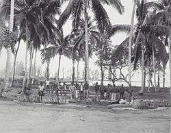
The regency was among the hardest-hit areas during the 2004 Indian Ocean earthquake.
The regency is bordered by the regencies of Aceh Jaya to the west, Pidie to the north, Central Aceh to the northeast, and Nagan Raya to the southeast, and by the Indian Ocean to the southwest.
Administrative divisions
The regency was divided administratively into twelve districts (kecamatan), listed below with their populations at the 2010 Census:[1]
- Johan Pahlawan (21 villages) - 56,050
- Samatiga (32 villages) - 13,322
- Bubon (17 villages) - 6,545
- Arongan Lambalek (23 villages) - 10,609
- Woyla (43 villages) - 12,073
- Woyla Barat (24 villages) - 6,858
- Woyla Timur (26 villages) - 4,138
- Kaway XVI (42 villages) - 18,753
- Meureubo (26 villages) - 26,510
- Pantai Ceuremen (25 villages) - 9,635
- Panton Reu (19 villages) - 5,671
- Sungai Mas (18 villages) - 3,394
However, on 8 July 2013 the city of Meulaboh was separated out of the regency to become an independent city.
See also
References
- 1 2 Biro Pusat Statistik, Jakarta, 2011.
- ↑ Indonesia. Departemen Penerangan; Japenpa Foreign Languages Publishing Institute (1975). Indonesia handbook. Dept. of Information, Republic of Indonesia. Retrieved 20 December 2010.
- ↑ Davies, Matthew N. (2006). Indonesia's war over Aceh: last stand on Mecca's porch. Taylor & Francis. pp. 21–. ISBN 978-0-415-37239-8. Retrieved 20 December 2010.
Regencies and cities of Aceh | ||
|---|---|---|
Capital: Banda Aceh | ||
| Regencies |  | |
| Cities | ||
| Authority control |
|---|