Abram S. Hewitt State Forest
| Abram S. Hewitt State Forest | |
|---|---|
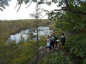 A group of hikers overlooking a lake in Abram S. Hewitt State Forest. | |
  | |
| Location | Passaic County |
| Coordinates | 41°11′8.5363″N 74°19′52.9500″W / 41.185704528°N 74.331375000°WCoordinates: 41°11′8.5363″N 74°19′52.9500″W / 41.185704528°N 74.331375000°W[1] |
| Area | 2,001-acre (8.10 km2) |
| Opened | 1951 |
| Operated by | New Jersey Division of Parks and Forestry |
| Website |
Official website |
Abram S. Hewitt State Forest is a state forest by Hewitt in northwestern New Jersey that is 2,001 acres (8.10 km2). It is on the Bearfort Ridge of unusual conglomerate between Greenwood Lake and Upper Greenwood Lake. Its forests are part of the Northeastern coastal forests ecoregion.[2] It has a number of overlooks and colorful bedrock. It is accessible only on foot, with trails including the Bearfort Trail, 3.0 miles (4.8 km) and white-blazed. Another trail is the Quail trail, 2.4 miles (3.9 km) and orange-blazed. Another is the Ernest Walter trail, 1.9 miles (3.1 km) and yellow-blazed. Also, the 1.2 miles (1.9 km) State Line trail is blazed with blue on white. Lastly, the Appalachian Trail traverses the forest's northwest corner along its route. The Appalachian Trail is approximately 2,200 miles (3,500 km) long.[3]
See Also
References
- ↑ http://www.state.nj.us/dep/parksandforests/parks/abram.html
- ↑ Olson, D. M; E. Dinerstein; et al. (2001). "Terrestrial Ecoregions of the World: A New Map of Life on Earth". BioScience. 51 (11): 933–938. doi:10.1641/0006-3568(2001)051[0933:TEOTWA]2.0.CO;2.
- ↑ http://www.nynjtc.org/park/abram-hewitt-state-forest
| Wikimedia Commons has media related to Abram S. Hewitt State Forest. |