Abiod Valley
| Oued el Abiod | |
|---|---|
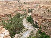 Abiod Valley near Ghoufi | |
| Native name | Ighzir Amellal |
| Other name(s) | Abiod Valley |
| Physical characteristics | |
| Main source |
Djebel Chélia 2,000 m |
| River mouth |
Near Tolga, Biskra Province 200 m |
| Length | 156 km |
| Basin features | |
| Basin size | 1,100 km |
| Tributaries | |
Oued El Abiod (English: Abiod Valley) is a wadi that forms a mountain pass in the Aurès massif, located in the Saharan Atlas in northeastern Algeria.[3] During the wet season, rain and melting snow flow into the valley to form the Abiod River. The valley begins at the foot of Djebel Chélia, Algeria's highest mountain, and flows southwest towards Tolga, eventually dissipating into the Sahara desert nearby.[3]
Geography
The vegetation in the highlands on the north end of the valley is typically Mediterranean with dense forests of oaks, pines and ancient cedars, sustained by the plentiful rainfall on the higher slopes.[3] The southern part is mainly desert with little vegetation. The valley has several minor oases which include the settlement of Ghoufi, situated within the valley.
References
- ↑ Mitard, A-E (1941). "Aperçu des grands traits géographiques de l'Aurès, Algérie". Revue de géographie alpine. 29 (4): 557–578 – via Persee.
- ↑ Busson, Henri (1900). "Les vallées de l'Aurès". Annales de Géographie. 9 (43): 43–55 – via Persee.
- 1 2 3 Scheffel, Richard L.; Wernet, Susan J., eds. (1980). Natural Wonders of the World. United States of America: Reader's Digest Association, Inc. p. 27. ISBN 0-89577-087-3.