A Line (RTD)
| A Line | |||||||||||||||||||||||||||||||||||||||||||||||||||||||||||||||||||||||||||||||||||||||||||||||||||||||||||||||||||||||||||||||||||||||||||||||||||||||||||||||||||||||||||||||||||||||||||||||||
|---|---|---|---|---|---|---|---|---|---|---|---|---|---|---|---|---|---|---|---|---|---|---|---|---|---|---|---|---|---|---|---|---|---|---|---|---|---|---|---|---|---|---|---|---|---|---|---|---|---|---|---|---|---|---|---|---|---|---|---|---|---|---|---|---|---|---|---|---|---|---|---|---|---|---|---|---|---|---|---|---|---|---|---|---|---|---|---|---|---|---|---|---|---|---|---|---|---|---|---|---|---|---|---|---|---|---|---|---|---|---|---|---|---|---|---|---|---|---|---|---|---|---|---|---|---|---|---|---|---|---|---|---|---|---|---|---|---|---|---|---|---|---|---|---|---|---|---|---|---|---|---|---|---|---|---|---|---|---|---|---|---|---|---|---|---|---|---|---|---|---|---|---|---|---|---|---|---|---|---|---|---|---|---|---|---|---|---|---|---|---|---|---|---|
|
| |||||||||||||||||||||||||||||||||||||||||||||||||||||||||||||||||||||||||||||||||||||||||||||||||||||||||||||||||||||||||||||||||||||||||||||||||||||||||||||||||||||||||||||||||||||||||||||||||
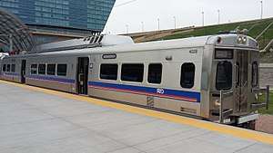 A Line train at the Denver Airport station | |||||||||||||||||||||||||||||||||||||||||||||||||||||||||||||||||||||||||||||||||||||||||||||||||||||||||||||||||||||||||||||||||||||||||||||||||||||||||||||||||||||||||||||||||||||||||||||||||
| Overview | |||||||||||||||||||||||||||||||||||||||||||||||||||||||||||||||||||||||||||||||||||||||||||||||||||||||||||||||||||||||||||||||||||||||||||||||||||||||||||||||||||||||||||||||||||||||||||||||||
| Type | Commuter rail | ||||||||||||||||||||||||||||||||||||||||||||||||||||||||||||||||||||||||||||||||||||||||||||||||||||||||||||||||||||||||||||||||||||||||||||||||||||||||||||||||||||||||||||||||||||||||||||||||
| System | Regional Transportation District | ||||||||||||||||||||||||||||||||||||||||||||||||||||||||||||||||||||||||||||||||||||||||||||||||||||||||||||||||||||||||||||||||||||||||||||||||||||||||||||||||||||||||||||||||||||||||||||||||
| Status | Operational | ||||||||||||||||||||||||||||||||||||||||||||||||||||||||||||||||||||||||||||||||||||||||||||||||||||||||||||||||||||||||||||||||||||||||||||||||||||||||||||||||||||||||||||||||||||||||||||||||
| Locale | Denver metropolitan area | ||||||||||||||||||||||||||||||||||||||||||||||||||||||||||||||||||||||||||||||||||||||||||||||||||||||||||||||||||||||||||||||||||||||||||||||||||||||||||||||||||||||||||||||||||||||||||||||||
| Termini |
Union Station Denver International Airport | ||||||||||||||||||||||||||||||||||||||||||||||||||||||||||||||||||||||||||||||||||||||||||||||||||||||||||||||||||||||||||||||||||||||||||||||||||||||||||||||||||||||||||||||||||||||||||||||||
| Stations | 8[1] | ||||||||||||||||||||||||||||||||||||||||||||||||||||||||||||||||||||||||||||||||||||||||||||||||||||||||||||||||||||||||||||||||||||||||||||||||||||||||||||||||||||||||||||||||||||||||||||||||
| Daily ridership | 18,000[2] | ||||||||||||||||||||||||||||||||||||||||||||||||||||||||||||||||||||||||||||||||||||||||||||||||||||||||||||||||||||||||||||||||||||||||||||||||||||||||||||||||||||||||||||||||||||||||||||||||
| Website | Official website | ||||||||||||||||||||||||||||||||||||||||||||||||||||||||||||||||||||||||||||||||||||||||||||||||||||||||||||||||||||||||||||||||||||||||||||||||||||||||||||||||||||||||||||||||||||||||||||||||
| Operation | |||||||||||||||||||||||||||||||||||||||||||||||||||||||||||||||||||||||||||||||||||||||||||||||||||||||||||||||||||||||||||||||||||||||||||||||||||||||||||||||||||||||||||||||||||||||||||||||||
| Opened | April 22, 2016 | ||||||||||||||||||||||||||||||||||||||||||||||||||||||||||||||||||||||||||||||||||||||||||||||||||||||||||||||||||||||||||||||||||||||||||||||||||||||||||||||||||||||||||||||||||||||||||||||||
| Owner | Regional Transportation District | ||||||||||||||||||||||||||||||||||||||||||||||||||||||||||||||||||||||||||||||||||||||||||||||||||||||||||||||||||||||||||||||||||||||||||||||||||||||||||||||||||||||||||||||||||||||||||||||||
| Operator(s) | Denver Transit Partners[3] | ||||||||||||||||||||||||||||||||||||||||||||||||||||||||||||||||||||||||||||||||||||||||||||||||||||||||||||||||||||||||||||||||||||||||||||||||||||||||||||||||||||||||||||||||||||||||||||||||
| Rolling stock | Hyundai Rotem, Silverliner V | ||||||||||||||||||||||||||||||||||||||||||||||||||||||||||||||||||||||||||||||||||||||||||||||||||||||||||||||||||||||||||||||||||||||||||||||||||||||||||||||||||||||||||||||||||||||||||||||||
| Technical | |||||||||||||||||||||||||||||||||||||||||||||||||||||||||||||||||||||||||||||||||||||||||||||||||||||||||||||||||||||||||||||||||||||||||||||||||||||||||||||||||||||||||||||||||||||||||||||||||
| Line length | 23.5 mi (37.82 km) | ||||||||||||||||||||||||||||||||||||||||||||||||||||||||||||||||||||||||||||||||||||||||||||||||||||||||||||||||||||||||||||||||||||||||||||||||||||||||||||||||||||||||||||||||||||||||||||||||
| Track gauge | 4 ft 8 1⁄2 in (1,435 mm) standard gauge | ||||||||||||||||||||||||||||||||||||||||||||||||||||||||||||||||||||||||||||||||||||||||||||||||||||||||||||||||||||||||||||||||||||||||||||||||||||||||||||||||||||||||||||||||||||||||||||||||
| Electrification | Overhead lines, 25kV AC[4] 60 Hz | ||||||||||||||||||||||||||||||||||||||||||||||||||||||||||||||||||||||||||||||||||||||||||||||||||||||||||||||||||||||||||||||||||||||||||||||||||||||||||||||||||||||||||||||||||||||||||||||||
| |||||||||||||||||||||||||||||||||||||||||||||||||||||||||||||||||||||||||||||||||||||||||||||||||||||||||||||||||||||||||||||||||||||||||||||||||||||||||||||||||||||||||||||||||||||||||||||||||
The A Line,[1] officially called the University of Colorado A Line for sponsorship reasons,[5] is a Regional Transportation District (RTD) commuter rail line serving Denver and Aurora, Colorado, operating between Downtown Denver and Denver International Airport (DIA).[6] During planning and construction the A line was also known as the East Rail Line, which sometimes it is still called.[7] Despite its official title, the line does not serve the campuses of the University of Colorado.
History
Mass transit has been under consideration for the corridor between Downtown Denver and Denver International Airport since the latter was proposed in the 1980s. The project gathered momentum in 1997 when a Major Investment Study was completed for the corridor, encouraging fixed-guideway mass transit (light rail or commuter rail), highway widening and general improvements. The project was approved as part of the FasTracks transit expansion package in November 2004, went through regulatory processes and was approved by the Federal Transit Administration in November 2009.[8] In July 2007, it was decided to use electric instead of diesel propulsion over speed and air pollution concerns.[9]
RTD designated the line with the letter “A”, denoting service to the airport and Aurora. Groundbreaking for the A Line was held on August 26, 2010.[10] As the second line of RTD’s FasTracks expansion plan, the East Corridor was constructed and operated under the Eagle P3 public–private partnership.[3] The first electric multiple unit railcars were pulled along the route on April 3, 2015, commencing testing and commissioning of the line.[11]
Revenue service began on April 22, 2016.[6][12] A software problem in the equipment closing the crossing gates has resulted in the use of traffic guards and frequent delays since the opening,[13] earning the project a slot on Westword's 2016 Colorado Hall of Shame.[14]
Operational Issues
Since the A line's opening in April 2016, it has had a number of operational issues. They range from power failure to crossing gate issues to broken rails along the line. Most of the delays have come from crossing gate issues. The main issues with the gates is they have been coming down too early and staying down too long, causing traffic backups. The Federal Railroad Administration (FRA) requires a minimum warning time of 20 seconds before the train enters the crossing. The current timing is well beyond this requirement. Because of this, human flaggers are required at each crossing along the line until this issue is resolved. This has been in place since the opening of the line. This is the main reason why the planned RTD G line is delayed. Until RTD can prove to the FRA that they have resolved the crossing gate issues, the G line will not be allowed to open. Today, RTD is making progress in fixing the crossing gate timing system along the A line. The A line shares crossings with Union Pacific tracks. This adds complexity to the crossing gate programs and technology.
In June 2018, the FRA approved a plan to remove the flaggers monitoring the crossing gates along the A line. This approval also allows local jurisdictions to submit requests to the FRA to establish "quiet zones", removing the need for trains crossing through the gates to blow their horns.[15]
Route
The A Line route follows and remains within a mile of Interstate 25, Interstate 70, and the airport access highway (Peña Boulevard). The line makes use of a preexisting Union Pacific Railroad right-of-way along the portion of the route from downtown Denver heading east, then deviates to the north along Peña Boulevard in newly created right-of-way. Peña Boulevard was designed with an extra wide median between its inbound and outbound lanes that could have been used for rail transit, though ultimately the East Rail Corridor alignment was offset from the highway right-of-way.
Leaving Union Station the line follows the Union Pacific corridor past Coors Field to reach a station at 38th and Blake Streets shared with the future Central Corridor expansion. From there the line turns east alongside 40th Avenue past the Denver Union Pacific Intermodal Yard. Just east of Josephine Street the corridor turns two blocks north then east again to stay along the Union Pacific corridor to reach the 40th Avenue and Colorado Boulevard station. After passing under Colorado Boulevard the line parallels Smith Road, with a station at Central Park Boulevard in the redevelopment area of the decommissioned Stapleton International Airport. Shortly after entering Aurora, the line reaches a station at Peoria Street, which will be shared with the new R Line. Continuing east, alongside Smith Road, the line passes under Peoria Street and then Interstate 225. Just west of Airport Boulevard, the line rises on a viaduct curving north over the Union Pacific tracks, Airport Boulevard, 32nd Avenue, and Interstate 70. Having left the Union Pacific corridor, the viaduct then descends to a station at the existing Park and Ride at 40th Avenue and Airport Boulevard. From there the line reenters Denver, following the east side of Peña Boulevard. North of 56th Avenue it enters a recently added[16] Peña Boulevard[1] station at 61st Avenue.[17][18] The line continues north and east, parallel to Peña Boulevard and crossing over E-470. Turning north, the line crosses over Peña Boulevard adjacent to DIA runway 7/25 and then runs east between the airport secure area and 78th Avenue. The line then crosses over the south/west terminal exit lanes of Peña Boulevard ending at a station on the south side of the DIA Hotel and Transit Center, itself at the south end of the DIA Jeppesen Terminal.[19][20]
Stations
| Name | Opening Year | Interchange | Municipality | Park & Ride (Capacity)[21] | |
|---|---|---|---|---|---|
| A Line (Union Station – Denver Airport) | |||||
| Union Station/ Lower Downtown (LoDo)/ Coors Field/16th Street Mall |
2014 | B & G Lines C , E , & W Lines FREE MallRide (16th St) |
Denver | No | |
| 38th & Blake | 2016 | Proposed L Line | Denver | Yes (200) | |
| 40th & Colorado | 2016 | None | Denver | Yes (200) | |
| Fare Zone Boundary | |||||
| Central Park | 2016 | None | Denver | Yes (1,500) | |
| Peoria | 2016 | R Line | Aurora | Yes (550) | |
| Fare Zone Boundary | |||||
| 40th Ave & Airport Blvd–Gateway Park | 2016 | None | Aurora | Yes (1,079) | |
| 61st & Peña[22][23] | 2016[1] | None | Denver | Yes (800; private lot) | |
| Fare Zone Boundary | |||||
| Denver Airport | 2016 | None | Denver | No | |
References
- 1 2 3 4 "RTD - A Line". RTD - A Line. Regional Transportation District. Retrieved June 21, 2015.
- ↑ Aguilar, John (April 9, 2017). "One year in: Denver's airport train navigates interruptions, a $6 million gate glitch and surprisingly strong ridership". Denver Post. Retrieved July 17, 2017.
- 1 2 "Eagle P3 Commuter Rail Project, Denver, USA". Railway Technology. Archived from the original on September 12, 2011. Retrieved September 1, 2011.
- ↑ "Commuter train testing begins on G Line". RTD FasTracks. Regional Transportation District of Denver. Retrieved July 25, 2016.
- ↑ Harden, Mark (August 19, 2015). "The A line goes to college: CU pays $5 million for RTD airport-rail naming rights". Denver Business Journal. Retrieved February 29, 2016.
- 1 2 "RTD - East Rail Line". Regional Transportation District. Retrieved April 29, 2015.
- ↑ "Stories Along the Line: East Rail to roll on historical ground". www.rtd-fastracks.com. Retrieved May 3, 2017.
- ↑ "Fastracks - East Corridor". Regional Transportation District. Retrieved April 29, 2010.
- ↑ "Electric Multiple Unit" (PDF). East Corridor Environmental Impact Statement. Archived from the original (PDF) on November 20, 2008. Retrieved July 23, 2014.
- ↑ "East Corridor Groundbreaking!". Denver Infill Blog. Archived from the original on September 12, 2011. Retrieved July 26, 2010.
- ↑ "Denver's new EMUs take "maiden voyage"". Railway Age. Retrieved April 7, 2015.
- ↑ "RTD service from Union Station to DIA scheduled to start April 22". The Denver Channel. Retrieved October 22, 2015.
- ↑ "Feds give RTD another 90 days fix A-Line crossing problems – The Denver Post". Retrieved February 6, 2017.
- ↑ http://www.westword.com/news/the-eight-inductees-into-the-2016-colorado-hall-of-shame-8622104
- ↑ "A-Line's noisy train horns' days are numbered, as RTD plans to pull flaggers back from six crossings starting Friday"". The Denver Post. Retrieved July 19, 2018.
- ↑ "New train station part of East Rail". rtd-fastracks.com. Regional Transportation District. Retrieved August 20, 2015.
- ↑ Hodes, David. "Colorado Experiences Phenomenal Success (with Photo)". Business Xpansion Journal. Retrieved June 15, 2015.
- ↑ "Eagle P3 Project update", Fast Tracks Monitor Committee, May 13, 2014
- ↑ "Hotel and Transit Center". FlyDenver.com. Archived from the original on July 2, 2015. Retrieved May 31, 2010.
- ↑ "Appendix A Preferred Alternate Maps" (PDF). East Corridor Environmental Impact Statement. Retrieved April 29, 2010.
- ↑ "University of Colorado A Line Stations & Parking". RTD. Retrieved April 23, 2016.
- ↑ "Peña Station Rail Stop", Flydenver.com, 2015
- ↑ "61st & Peña Station Area Plan" Archived June 21, 2015, at the Wayback Machine., City and County of Denver, January 13, 2014
External links
Route map:
| Operators |
| ||||||||||||
|---|---|---|---|---|---|---|---|---|---|---|---|---|---|
| Rail service |
| ||||||||||||
| Bus service | |||||||||||||
| Other topics | |||||||||||||