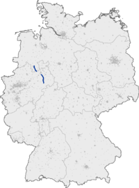
Bundesautobahn 33
| ||||
|---|---|---|---|---|
| Bundesautobahn 33 | ||||
 | ||||
| Route information | ||||
| Length | 89 km (55 mi) | |||
| Location | ||||
| States | North Rhine-Westphalia, Lower Saxony | |||
| Highway system | ||||
| ||||
Bundesautobahn 33 (translates from German as Federal Motorway 33, short form Autobahn 33, abbreviated as BAB 33 or A 33) is an autobahn in Germany which connects the Bundesautobahn 30 in the north and the A 44 in the south.
History
The history of the A 33 began in the 1960s as the B 68. It was intended that the route would be extended northwards to reach Bramsche, and to this day, the B 68 has been partially extended between Osnabrück and Bramsche in a similar fashion to an Autobahn.
Two major gaps currently exist in the A 33. Plans to close the 9 km long gap between the A 33 and the A 1 around Osnabrück are underway, the selected route having been submitted by the planning authority of Lower Saxony to the Federal Ministry of Transport, Building and Urban Development (BMVBS) for approval. A larger (about 13 km) gap exists between the end of the Autobahn at the exit for Borgholzhausen and Halle (Westf.)-Künsebeck. The segment from the south of Bielefeld (B 61) to Steinhagen is completed in April 2018. The remaining section from Steinhagen to Borgholzhausen via Halle (in North Rhine-Westphalia) is still under litigation, with an estimated commencement of construction in December 2012.
Route
The A 33 begins to the east of Osnabrück in Schinkel, crossing over the A 30 to Osnabrück Süd, running through Georgsmarienhütte, Hilter am Teutoburger Wald, Bad Rothenfelde and Dissen am Teutoburger Wald, ending after around 25 km in Borgholzhausen. At this point, there are considerable traffic jams on the linking B 68, as the area is not equipped to handle all the incoming traffic from the A 33.
From Halle (Westf.)-Künsebeck, around 13 km southeast of Borgholzhausen, the A 33 begins a new, running through Bielefeld, Sennestadt, Schloß Holte-Stukenbrock, Paderborn and Borchen before terminating at the Bad Wünnenberg interchange, which joins the A 44 running between Dortmund and Kassel as well as the B 480, which leads on through Brilon in the Sauerland region.
Route names
The three different stretches of road are named according to the region in which they are located. The Osnabrück-Bielefeld route is known as the Teutoburger-Wald-Autobahn, the route between Bielefeld and Paderborn, which feeds into the A 2, is known as the Senneautobahn, and the remainder leading through East Westphalia is known as the Ostwestfalenmagistrale.
Notable features
Between junctions Dissen and Dissen Süd, a tunnel has been built of around 700 m length to protect the surrounding area from the noise.
Exit list
| 3-way interchange Wallenhorst (planned) | ||
| Ostercappeln (planned) | ||
| Belm (under construction) | ||
| Osnabrück-Schinkel (under construction) | ||
| (7) | Osnabrück-Lüstringen | |
| Hochstraße Schinkel 180 m | ||
| Hase | ||
| (8) | Osnabrück-Fledder | |
| (9) | Osnabrück-Süd 4-way interchange | |
| (10) | Harderberg | |
| (11) | Borgloh/Kloster Oesede | |
| Rest area Teutoburger Wald | ||
| (12) | Hilter a.T.W. | |
| Grünbrücke 20 m | ||
| (13) | Dissen/Bad Rothenfelde | |
| Tunnel Lärmschutztunnel 700 m | ||
| (14) | Dissen-Süd | |
| (15) | Borgholzhausen | |
| Grünbrücke 40 m | ||
| Grünbrücke 40 m | ||
| Grünbrücke 20 m | ||
| Grünbrücke 50 m | ||
| Grünbrücke 20 m | ||
| Grünbrücke 40 m | ||
| Halle (under construction) | ||
| (17) | Halle-Künsebeck | |
| Foddenbachbrücke 56 m | ||
| Jückemühlenbachbrücke 65 m | ||
| Pulverbachbrücke 61 m | ||
| (18) | Steinhagen | |
| Lutterbrücke 100 m | ||
| (19) | Bielefeld-Zentrum 3-way interchange | |
| Grünbrücke 30 m | ||
| (20) | Bielefeld-Senne | |
| (21) | Bielefeld 4-way interchange | |
| (22) | Schloß Holte-Stukenbrock | |
| (23) | Stukenbrock-Senne | |
| Rest area Hövelsenne | ||
| Rest area Hövelsenne (planned) | ||
| (24) | Paderborn-Sennelager | |
| Rest area Lippesee | ||
| Lippebrücke 110 m | ||
| (25) | Paderborn-Schloß Neuhaus | |
| (26) | Paderborn-Elsen | |
| (27) | Paderborn-Zentrum interchange | |
| Talbrücke Barkhausen 290 m | ||
| (28) | Paderborn-Mönkeloh | |
| Talbrücke Lohme-Alme 750 m | ||
| Talbrücke Alme 370 m | ||
| (29) | Borchen | |
| Rest area Letzter Heller | ||
| (30) | Etteln | |
| (31) | Wünnenberen-Haaren 4-way interchange | |
| End of the motorway | ||
|
| ||
External links
- Bundesautobahn 33 – detailed route plan (in German)