Schloß Holte-Stukenbrock
| Schloß Holte-Stukenbrock | |||
|---|---|---|---|
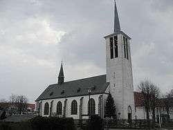 St. Ursula Church in Schloß Holte | |||
| |||
 Schloß Holte-Stukenbrock Location of Schloß Holte-Stukenbrock within Gütersloh district 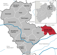  | |||
| Coordinates: 51°53′N 8°37′E / 51.883°N 8.617°ECoordinates: 51°53′N 8°37′E / 51.883°N 8.617°E | |||
| Country | Germany | ||
| State | North Rhine-Westphalia | ||
| Admin. region | Detmold | ||
| District | Gütersloh | ||
| Government | |||
| • Mayor | Hubert Erichlandwehr (CDU) | ||
| Area | |||
| • Total | 67.42 km2 (26.03 sq mi) | ||
| Elevation | 140 m (460 ft) | ||
| Population (2016-12-31)[1] | |||
| • Total | 26,770 | ||
| • Density | 400/km2 (1,000/sq mi) | ||
| Time zone | CET/CEST (UTC+1/+2) | ||
| Postal codes | 33758 | ||
| Dialling codes | 05207 | ||
| Vehicle registration | GT | ||
| Website | schloss-holte-stukenbrock.de | ||

Schloß Holte-Stukenbrock is a city in the district of Gütersloh in the state of North Rhine-Westphalia, Germany. It is located near the Eggegebirge, approx. 15 km east of Gütersloh and 15 km south-east of Bielefeld. It is the source of the Ems River. In 2004, the town celebrated its 850th Anniversary, making it one of the oldest towns in North Rhine-Westphalia.
References
- ↑ "Amtliche Bevölkerungszahlen" (in German). Landesbetrieb Information und Technik NRW. Retrieved 2018-02-24.
Towns and municipalities in Gütersloh (district) | ||
|---|---|---|
| Authority control |
|---|
This article is issued from
Wikipedia.
The text is licensed under Creative Commons - Attribution - Sharealike.
Additional terms may apply for the media files.