A roads in Zone 9 of the Great Britain numbering scheme
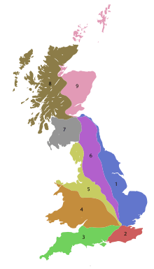
The numbering zones for A-roads in Great Britain
List of A roads in zone 9 in Great Britain starting north of the A8, east of the A9 (roads beginning with 9).
Single- and double-digit roads
| Road | From | To | Notes |
|---|---|---|---|
| Falkirk | Scrabster | Formerly to John o' Groats | |
| Edinburgh | Fraserburgh | via Perth and Aberdeen | |
| St Andrews | Bannockburn | ||
| Dunfermline | Stonehaven | ||
| Perth | Aberdeen | via Braemar | |
| Perth | Forfar | via Coupar Angus | |
| Aviemore | Banff | ||
| Aberdeen | Inverness | Originally ran along Gallowgate on the east end. This was discontinued, and A96 was rerouted over the A946. | |
| Banff | Dinnet | ||
| Fraserburgh | Fochabers | ||
| Latheron | John o' Groats | An older routing went from A80 in Pirnhall to A9 in Bannockburn (now A91). |
Triple-digit roads
| Road | From | To | Notes |
|---|---|---|---|
| Edinburgh | Leith | ||
| Leith | Granton | ||
| Leith | North Gyle | ||
| Granton | Trinity | ||
| South Queensferry | Falkirk | ||
| Grangemouth | Stirling | ||
| Stirling | Crossgates | ||
| Alloa | Tillicoultry | ||
| Burntisland | Kelty | ||
| Kirkcaldy | Kirkcaldy | ||
| Windygates | Milnathort | ||
| Perth | Muirhead | ||
| Cupar | Aberargie | ||
| Muirhead | Newport-on-Tay | ||
| Kirkcaldy | St Andrews | ||
| Windygates | Cupar | ||
| Largo | St Andrews | Coast road via Crail | |
| St Andrews | St Andrews | ||
| St Michaels | Guardbridge | ||
| Ellon | Dufftown | ||
| Kirkcaldy | M90 motorway | ||
| Kinross | Kinross | ||
| Dundee | Dunkeld | ||
| Pitlochry | Bridge of Cally | ||
| Forfar | Blairgowrie | ||
| Kirriemuir | Todhills | ||
| Dundee | Dundee | ||
| Dundee | Carnoustie | ||
| Forfar | Friockheim | ||
| Brechin | Arbroath | ||
| Montrose | Glasterlaw | ||
| Brechin | Montrose | ||
| Laurencekirk | Montrose | ||
| Carrbridge | Dulnain Bridge | ||
| Nairn | Ballater | ||
| Forres | Dava | ||
| Lossiemouth | Rhynie | ||
| Cullen | Buckie | ||
| Aberdeen | Corgarff | ||
| A945 road | Bridge of Dee | Aberdeen | |
| A946 | Unused | Ran from A96 (now Gallowgate) in Kittybrewster to A956 Aberdeen Docks (now A96). | |
| Aberdeen | Banff | ||
| Ellon | New Deer | Formerly continued to Turriff | |
| Dornoch | Bonar Bridge | ||
| Peterhead | A98 at New Pitsligo | ||
| Toll of Birness | Cortes | ||
| A97, Castle Street, Banff | Harbour Place, Banff | Quayside. 300yds long. | |
| Kirkcaldy | Leven | ||
| Bridge of Don, Aberdeen | Charlestown, Aberdeen | Wellington Rd, Market St and King St, Aberdeen | |
| Stonehaven | Crathes | Known as the Slug Road | |
| Kirkwall | Deerness | ||
| Kirkwall | Burwick | ||
| Broad Street, Kirkwall | Junction Road, Kirkwall | West Castle Street | |
| Kirkwall | Junction with A961 | ||
| Kirkwall | Junction with A965 | ||
| Kirkwall | Stromness | ||
| Finstown | Birsay | ||
| Stromness | Birsay | ||
| Voe | Haroldswick | Includes two ferry crossings | |
| Lerwick | Lerwick | ||
| Sumburgh | North Roe | Spurs to Scalloway and Hillswick | |
| Tingwall | Sandness | Spur to Walls | |
| Dundee | Dundee | ||
| A90 (Rashierieve nr Newburgh) | Longhaven (A90) | Aberdeen–Peterhead coastal route | |
| Kincardine Bridge | Kinross | ||
| Union Street, Aberdeen | King Street, Aberdeen | ||
| Alford, Aberdeenshire | Banchory | ||
| New Deer | Fraserburgh | Formerly from Inverurie | |
| Peterhead, South A90 Junction | Peterhead, North Road (A90) | ||
| Coupar Angus | Dunkeld | ||
| Kincardine | Inverkeithing | Now incorporates the Kincardine Bridge. | |
| Finstown | Twatt | ||
| A987 | Unused | Ran from Kirkcaldy to Aberdour (now B9157). | |
| A988 | Unused | Ran from A921 to A910 (now B981). | |
| Perth | Perth | Perth Inner Ring Road | |
| Broadley | Buckie | ||
| Dundee | Dundee | Dundee Inner Ring Road | |
| Bo'ness | Muirhouses | ||
| Dunfermline | Cairneyhill, at Cairneyhill Roundabout |
Four-digit roads
| Road | From | To | Notes |
|---|---|---|---|
| A9000 road | New road created on 30 August 2017 as a renumbering of the A90 over the Forth Road Bridge as the Queensferry Crossing opened. | ||
| Ashgrove, Aberdeen | Stockethill, Aberdeen | ||
| Ashgrove, Aberdeen | Northfield, Aberdeen | ||
| A90 Bridge of Dee, Aberdeen | King Street, Aberdeen | Holburn Street and Union Street |
This article is issued from
Wikipedia.
The text is licensed under Creative Commons - Attribution - Sharealike.
Additional terms may apply for the media files.