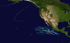
1975 Pacific Northwest hurricane
| Category 1 hurricane (SSHWS/NWS) | |
.PNG) The hurricane near peak intensity on September 3 | |
| Formed | August 31, 1975 |
|---|---|
| Dissipated | September 5, 1975 |
| Highest winds |
1-minute sustained: 75 mph (120 km/h) |
| Lowest pressure | 990 mbar (hPa); 29.23 inHg |
| Fatalities | None reported |
| Damage | None |
| Areas affected | British Columbia, Yukon, Alaska, Washington, Oregon |
| Part of the 1975 Pacific hurricane season | |
The 1975 Pacific Northwest hurricane was an unusual Pacific tropical cyclone that attained hurricane status farther north than any other Pacific hurricane. It was officially unnamed, with the cargo ship Transcolorado providing vital meteorological data in assessing the storm. The twelfth tropical cyclone of the 1975 Pacific hurricane season, it developed from a cold-core upper-level low merging with the remnants of a tropical cyclone on August 31, well to the northeast of Hawaii. Convection increased as the circulation became better defined, and by early on September 2 it became a tropical storm. Turning to the northeast through an area of warm water temperatures, the storm quickly strengthened, and, after developing an eye, it attained hurricane status late on September 3, while located about 1,200 miles (1,950 km) south of Alaska. After maintaining peak winds for about 18 hours, the storm rapidly weakened, as it interacted with an approaching cold front. Early on September 5, it lost its identity near the coast of Alaska.
Meteorological history
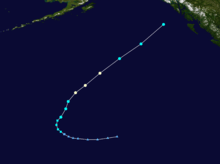
On August 26, the tropical cyclone that was once Hurricane Ilsa degenerated into a remnant low-pressure area, about 1,200 miles (1,950 km) west of the southern tip of the Baja California Peninsula.[1] The remnants of Ilsa drifted northwestward through the stratocumulus cloud field of the eastern north Pacific Ocean.[2] At the same time, a mid-tropospheric trough slowly intensified while gradually undergoing cyclogenesis to develop into a cold-core upper-level low.[3] Early on August 31, a low-level circulation formed within the upper-level low about 930 miles (1,500 km) northeast of Hawaii;[4] at that time, the circulation and the remnants of Ilsa were located within 370 miles (600 km) of each other. The cold-core low rapidly intensified as convection increased, and late on August 31 it absorbed the remnants of Ilsa,[2] which influenced the development of the system.[3] Convection steadily organized as it tracked westward, and it is estimated it transitioned into a subtropical depression by 18:00 UTC on September 1.[3]
With warm water temperatures,[3] the system strengthened and began to develop tropical characteristics. Subsequent to the development of banding features, convection contracted and deepened over the increasingly well-defined center, and is estimated it became a tropical storm by early on September 2 while located about 685 miles (1,100 km) north of the Hawaiian island of Kauai. The storm quickly developed a central dense overcast, and by 00:00 UTC on September 3 Dvorak classifications began on the cyclone.[2] With water temperatures of over 82 °F (28 °C),[3] it strengthened rapidly as an approaching cold front caused it to accelerate to the northeast. An eye became apparent on satellite imagery, and the storm intensified into a hurricane at 18:00 UTC on September 3, while located about 1,170 miles (1,885 km) south of Aniakchak National Monument and Preserve in Alaska.[2] Upon becoming a hurricane, the cyclone was small, measuring about 85 miles (140 km) in diameter.[3]
Operationally, the hurricane was not classified due to lack of ship confirmation; by the time it became a hurricane, the strongest winds reported by a ship was 40 mph (65 km/h) about 80 miles (130 km) southeast of the center. Additionally, upon developing a closed eyewall, the cyclone was beginning to interact with the frontal system to its west. However, late on September 3, a ship reported a pressure of 1003 mbar with a 3-hour tendency increase of 13.5 mb, suggesting a minimum pressure of under 990 mbar.[2] At the time, the storm maintained a T-number of 4.0, resulting in estimated winds of 75 mph (120 km/h) and an estimated pressure of 987 mbar.[3] Maintaining hurricane status for about 18 hours, the storm continued rapidly northeastward and weakened, due to strong wind shear from the approaching cold front. Early on September 5, it is estimated the cyclone became extratropical in the Gulf of Alaska, while located about 315 miles (510 km) southwest of Juneau, Alaska. On the same day, the circulation was rapidly absorbed by the frontal system,[2] and the remnants quickly reached the coast of British Columbia.[3] The remnants of the storm turned southeastward, and was last tracked definitively to a point north of Montana.[2]
Impact and records
.png)
At 18:00 UTC on September 3, a ship named Pluvius recorded 50 mph (85 km/h) winds near the center of the storm. At 06:00 UTC on September 4, the U.S. Navy-chartered cargo ship Transcolorado recorded winds of 65 mph (100 km/h) about 120 miles (200 km),[1] the strongest reported winds in association with the tropical cyclone; the ship also reported 27 foot (8.5 m) swells.[2] No significant land impact occurred in association with the cyclone, and no fatalities were reported.[3]
Forming at 31° N, the storm formed farther north than any other Pacific tropical cyclone at the time, though, in 2000, Tropical Storm Wene formed farther to the north.[4] The cyclone marked the first known occurrence of a mid-Pacific upper tropospheric low developing into a tropical cyclone,[5] though Tropical Storm Fausto in 2002 redeveloped in a similar occurrence to the hurricane.[6] The cyclone attained hurricane status at 40° N, a record for a Pacific hurricane. Only Tropical Storm Dot in 1970, Hurricane John in 1994, Tropical Depression Guillermo in 1997, and Tropical Storm Wene in 2000 were tropical cyclones north of the latitude, of which only John was a hurricane; none maintained tropical cyclone status further north than the cyclone.[4]
See also
References
- 1 2 Robert A. Baum (1976). "Eastern North Pacific Tropical Cyclones of 1975". Monthly Weather Review (PDF). American Meteorology Society. 104 (4): 475. Bibcode:1976MWRv..104..475B. doi:10.1175/1520-0493(1976)104<0475:ENPTCO>2.0.CO;2.
- 1 2 3 4 5 6 7 8 Donald Cochran (1976). "Unusual Tropical Development from a Mid-Pacific Cold Low". Monthly Weather Review (PDF). American Meteorology Society. 104 (6): 804. Bibcode:1976MWRv..104..804C. doi:10.1175/1520-0493(1976)104<0804:UTDFAM>2.0.CO;2.
- 1 2 3 4 5 6 7 8 9 Thomas Burtt; Dennis Haller (1976). "An Unusual Tropical Cyclone in the North Central Pacific". Monthly Weather Review. 104 (3): 321. Bibcode:1976MWRv..104..321B. doi:10.1175/1520-0493(1976)104<0321:AUTCIT>2.0.CO;2. Retrieved July 10, 2007.
- 1 2 3 National Hurricane Center; Hurricane Research Division; Central Pacific Hurricane Center. "The Northeast and North Central Pacific hurricane database 1949–2017". United States National Oceanic and Atmospheric Administration's National Weather Service. A guide on how to read the database is available here.
- ↑ Central Pacific Hurricane Center. "The 1975 Central Pacific Tropical Cyclone Season". Retrieved July 10, 2007.
- ↑ Central Pacific Hurricane Center. "The 2002 Central Pacific Tropical Cyclone Season". Retrieved July 10, 2007.