1901 Cheviot earthquake
 | |
| UTC time | ?? |
|---|---|
| ISC event | |
| USGS-ANSS | |
| Local date | 16 November 1901 |
| Local time | 07:47 NZT |
| Magnitude | 6.9 |
| Depth | 33 km |
| Areas affected | South Island, New Zealand |
| Casualties | 1 death |
The 1901 Cheviot earthquake occurred at 07:47 NZT on 16 November 1901 with an estimated magnitude of 6.9, centred near the township of Cheviot in the Canterbury Region of New Zealand.
Damage and casualties
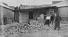
A baby was killed when a sod hut collapsed.[1] Other casualties in the Canterbury region are not known.
The ChristChurch Cathedral experienced some damage in this earthquake. The top of the spire fell again as a result of the 16 November 1901 Cheviot earthquake. This time, the stone construction was replaced with a more resilient structure of Australian hardwood sheathed with weathered copper sheeting, with an internal mass damper.
Observations of sand blows (sand volcano) and lateral spreading, consistent with soil liquefaction phenomena in the township of Kaiapoi were reported in local newspapers in a two to three block area at the eastern end of Charles and Sewell Streets on the north bank of the Kaiapoi River, in addition to similar effects observed on the opposing river bank, and the road to Belfast.[2]
See also
External links
- "School interior after earthquake (photo)". Otago Witness in Papers Past. 27 November 1901.
- "McTaggart's shop (photo of front)". Otago Witness in Papers Past. 27 November 1901.
- "McTaggart's shop (photo of back)". Otago Witness in Papers Past. 27 November 1901.
- "Cartoon: Who are you?". Observer in Papers Past. 30 November 1901.
- "Cartoon: Hon Hall-Jones contemplating the ruins". Observer in Papers Past. 30 November 1901.
- "Cartoon: Another injustice to Auckland by Dick Seddon!". Observer in Papers Past. 23 November 1901.
References
| Wikimedia Commons has media related to 1901 Cheviot earthquake. |
- ↑ This Week in History, GNS Science
- ↑ Berrill, J.B.; Mulqueen, P.C.; Ooi E.T.C. (1994). "Liquefaction at Kaiapoi in the 1901 Cheviot, New Zealand, Earthquake". Bulletin of the New Zealand National Society of Earthquake Engineering. 27: 178–189.