Šalčininkai District Municipality
| Šalčininkai District Municipality Šalčininkų rajono savivaldybė Gmina rejonowa Soleczniki | ||
|---|---|---|
| Municipality | ||
2011.jpg) Landscape near Barkuškės | ||
| ||
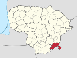 Location of Šalčininkai District Municipality | ||
| Country |
| |
| Ethnographic region | Dzūkija | |
| County |
| |
| Capital | Šalčininkai | |
| Elderships |
List
| |
| Area | ||
| • Total | 1,491 km2 (576 sq mi) | |
| Population (2017 census) | ||
| • Total | 31 821 | |
| Time zone | UTC+2 (EET) | |
| • Summer (DST) | UTC+3 (EEST) | |
| Website |
www | |

Šalčininkai District Municipality (Lithuanian: Šalčininkų rajonas) is one of 60 municipalities in Lithuania. It has one of biggest Polish minority populations in Lithuania, with 31,821 or 77,75% (2011 census) of the population claiming Polish ethnicity.[1] Šalčininkai is the largest town in and the administrative center of the district.
The south-eastern border of the municipality with Belarus includes a distinctive salient of Lithuanian territory almost completely surrounded by Belarus.
Lithuanian Route 104 passes through the district.
The Poškonys Reservoir (Poškonių tvenkinys) with an area of 0.3 km2 on the Gauja River is located in the district.
References

Coordinates: 54°20′13″N 25°22′52″E / 54.33694°N 25.38111°E
This article is issued from
Wikipedia.
The text is licensed under Creative Commons - Attribution - Sharealike.
Additional terms may apply for the media files.