Święta Lipka
| Święta Lipka | |
|---|---|
| Village | |
 Święta Lipka basilica | |
 Święta Lipka | |
| Coordinates: 54°2′N 21°13′E / 54.033°N 21.217°E | |
| Country |
|
| Voivodeship | Warmian-Masurian |
| County | Kętrzyn |
| Gmina | Reszel |
| Population | 200 |
Święta Lipka [ˈɕfjɛnta ˈlipka]; German: Heiligelinde) is a village in the administrative district of Gmina Reszel, within Kętrzyn County, Warmian-Masurian Voivodeship, in northern Poland.[1] It lies approximately 6 kilometres (4 mi) south-east of Reszel, 13 km (8 mi) south-west of Kętrzyn, and 55 km (34 mi) north-east of the regional capital Olsztyn. The village has a population of about 200 and was part of East Prussia until the end of World War II.
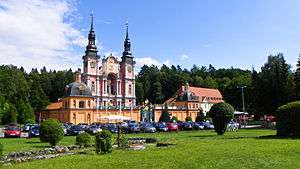
The village is known for the pilgrimage church, Our Dear Lady of Święta Lipka, a masterpiece of Baroque architecture.
Sanctuary of St. Mary

According to legend, the name Heiligelinde (Holy Linden tree) Święta Lipka - Holy Tilia (lime tree) - referred to a tree with a wooden statue of Mary under which miracles took place, though it may stem from a sacred grove of the Old Prussians.
A chapel at the site was first mentioned in a 1491 deed issued by Johann von Tiefen, then Grand Master of the Teutonic Knights. At this time Heiligelinde was already a pilgrimage site, with an inn. It was destroyed about 1525 during the Protestant Reformation, during which the region became Lutheran.
Although the village lay in the protestant region of Masuria, the Roman Catholic faith was again approved in the East Prussia in 1605.[2] The chapel was rebuilt by the Jesuits and consecrated in 1619 by the Warmian prince-bishop Szymon Rudnicki and became a popular pilgrimage site among the Roman Catholic populace of the surrounding counties as well as the Lutheran Masurians.[2] The nave of the present church was finished in 1693, the facade and the adjacent cloister added by 1730.
References
- ↑ "Central Statistical Office (GUS) - TERYT (National Register of Territorial Land Apportionment Journal)" (in Polish). 2008-06-01.
- 1 2 Ossowski, Miroslaw (2007). Ostpreussen - Westpreussen - Danzig: eine historische Literaturlandschaft (in German). Jens Stüben. p. 384. ISBN 978-3-486-58185-0. Retrieved 2009-10-28.
External links
- (in Polish) Official site
- Święta Lipka Jesuits
| Wikimedia Commons has media related to St. Mary Church in Święta Lipka. |

Coordinates: 54°2′N 21°13′E / 54.033°N 21.217°E