Đồng Văn District
| Ha Giang District Tinh Ha giang | |
|---|---|
| Rural district | |
| Country |
|
| Region | Northeast |
| Province | Ha Giang |
| Capital | Phó Bảng |
| Area | |
| • Total | 447 km2 (173 sq mi) |
| Population (2003) | |
| • Total | 57,715 |
| Time zone | UTC+7 (UTC + 7) |
Residence of Hmong Lord on the Turtle Hill in Sà Phìn commune, Đồng Văn district, Hà Giang province.
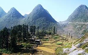
Đồng Văn is a rural district of Ha Giang province in the Northeast region of Vietnam. As of 2003, the district had a population of 57,715.[1] The district covers an area of 447 km². The district capital lies at Phó Bảng.[1]
Administrative divisions
Đồng Văn, Phó Bảng, Hố Quáng Phìn, Lũng Cú, Lũng Phìn, Lũng Táo, Lũng Thầu, Má Lé, Phố Cáo, Phố Là, Sà Phìn, Sảng Tủng, Sính Lủng, Sủng Là, Sủng Trái, Tả Lủng, Tả Phìn, Thài Phìn Tủng, Vần Chải
References
| Wikivoyage has a travel guide for Dong Van. |
- 1 2 "Districts of Vietnam". Statoids. Retrieved March 13, 2009.
| Bắc Giang Province |  | |
|---|---|---|
| Bắc Kạn Province | ||
| Cao Bằng Province | ||
| Hà Giang Province | ||
| Lạng Sơn Province | ||
| Phú Thọ Province | ||
| Quảng Ninh Province | ||
| Thái Nguyên Province | ||
| Tuyên Quang Province | ||
※ denotes provincial seat. | ||
Coordinates: 23°16′48″N 105°21′49″E / 23.2800°N 105.3636°E
This article is issued from
Wikipedia.
The text is licensed under Creative Commons - Attribution - Sharealike.
Additional terms may apply for the media files.