Čohovo
| Čohovo | |
|---|---|
 | |
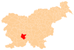
 Čohovo Location in Slovenia | |
| Coordinates: 45°51′14.33″N 14°27′50.17″E / 45.8539806°N 14.4639361°ECoordinates: 45°51′14.33″N 14°27′50.17″E / 45.8539806°N 14.4639361°E | |
| Country |
|
| Traditional region | Inner Carniola |
| Statistical region | Littoral–Inner Carniola |
| Municipality | Cerknica |
| Area | |
| • Total | 0.75 km2 (0.29 sq mi) |
| Elevation | 850.1 m (2,789.0 ft) |
| Population (2002) | |
| • Total | 0 |
| [1] | |
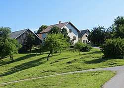
Čohovo (pronounced [ˈtʃoːxɔʋɔ] or [tʃɔˈxɔːʋɔ] or [-ˈxoː-])[2] is a small abandoned settlement above Sveti Vid in the Municipality of Cerknica in the Inner Carniola region of Slovenia.[3]
Geography
Čohovo is a clustered village on the southwest slope of Čoh Hill (Čohov grič, 870 meters or 2,850 feet), which is covered in needleleaf forest. It stands along the road from Osredek to Ravne. Beden Spring lies below the village toward the Iška River and was used in the past for as a water source for the village. Štembuh Spring, located near the wayside shrine in Čohovo, was outfitted with a trough for watering animals.[4]
References
- ↑ Statistical Office of the Republic of Slovenia
- ↑ Jakopin, Franc, et al. 1985. Slovenska krajevna imena. Ljubljana: Cankarjeva založba, p. 45.
- ↑ Cerknica municipal site
- ↑ Savnik, Roman (1968). Krajevni leksikon Slovenije, vol. 1. Ljubljana: Državna založba Slovenije. p. 42.
External links

- Čohovo on Geopedia
| Settlements | Administrative centre: Cerknica
|  |
|---|---|---|
| Landmarks | ||
This article is issued from
Wikipedia.
The text is licensed under Creative Commons - Attribution - Sharealike.
Additional terms may apply for the media files.