Čair Municipality
| Municipality of Čair Општина Чаир / Komuna Çair | |||
|---|---|---|---|
| City municipality (Urban) | |||
| |||
 | |||
| Coordinates: 42°0′7″N 21°26′17″E / 42.00194°N 21.43806°ECoordinates: 42°0′7″N 21°26′17″E / 42.00194°N 21.43806°E | |||
| Country |
| ||
| Region | Skopje Statistical Region | ||
| Municipal seat | Skopje | ||
| Government | |||
| • Mayor | Visar Ganiu (DUI) | ||
| Area | |||
| • Total | 3.52 km2 (1.36 sq mi) | ||
| Population | |||
| • Total | 64,773 | ||
| • Density | 18,400/km2 (48,000/sq mi) | ||
| Time zone | UTC+1 (CET) | ||
| Website | http://cair.gov.mk/ | ||


Čair (Macedonian: ![]()
Geography
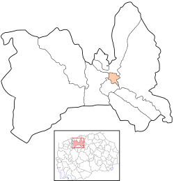
Čair is located along the northern (left) bank of the Vardar River, opposite the modern city center. It borders Centar Municipality to the southwest, Karpoš Municipality to the west, Butel Municipality to the north, and Gazi Baba Municipality to the east.
History
Skopje's old town, or Stara Čaršija, had been the city's main center at least since the 12th century. Turkish influence is dominant in the Stara Čaršija. The old town has not changed much over time; it is still filled with narrow cobblestone walkways and most of the Ottoman monuments are still standing.
Skanderbeg Square is located in Çair. Ethnic Albanians living in the Macedonian capital planned to build a second city square, widely seen as their rival to the government’s “Skopje 2014” revamp scheme.[1]
Demographics
According to the last national census from 2002, Čair has 64,773 inhabitants.[2] Ethnic groups in the municipality include:
- Albanians = 36,921 (57.0%)
- Macedonians = 15,628 (24.1%)
- Turks = 4,500 (6.9%)
- Roma = 3,083 (4.8%)
- Bosniaks = 2,950 (4.6%)
- others = 1,691 (2.6%)
External links
Notes
- ↑ Sinisa Jakov Marusic (27 September 2010). "Skopje's Albanians Plan 'Alternative' City Square". Skopje: Balkan Insight. Retrieved 2 March 2018.
- ↑ 2002 census results in English and Macedonian (PDF)
| Municipalities |  | |
|---|---|---|
| Geography | ||
| History | ||
| Landmarks | ||
| Churches | ||
| Mosques | ||
| Museums | ||
| Sports venues | ||
| Sports clubs |
| |
| Education | ||
| Events | ||
| Transportation | ||
| People | ||
The municipality names in italics have an Albanian population of over 50% but below 60%. Names in brackets are Albanian equivalents of the Macedonian names. |