Ćićarija
| Ćićarija | |
|---|---|
| Slovene: Čičarija, Italian: Cicceria, German: Tschitschen Boden | |
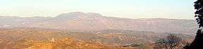 Ćićarija seen from Gračišće | |
| Highest point | |
| Elevation | 1,272 m (4,173 ft) |
| Coordinates | 45°21′38″N 14°11′31″E / 45.36056°N 14.19194°ECoordinates: 45°21′38″N 14°11′31″E / 45.36056°N 14.19194°E |
| Geography | |
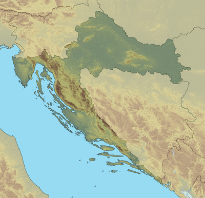 Ćićarija Location of Ćićarija in Croatia (on the border with Slovenia) | |
| Location | Croatia-Slovenia border in Istria |
Ćićarija (Slovene: Čičarija, Italian: Cicceria, Monti della Vena, German: Tschitschen Boden), is a mountainous plateau in the northern and north-eastern part of Istria peninsula, 45 km long and 10–15 km wide. It mostly lies in Croatia, while its northern part lies in southwestern Slovenia (the traditional region of Inner Carniola). The highest peak is Veliki Planik at 1,272 m.a.s.l.[1]
At 7 inhabitants per square kilometer (2001), Ćićarija is sparsely populated, due to its karst landscape, poor economic development and rough climate.
Name
The name Ćićarija is derived from the South Slavic term Ćić, which refers to Istrians living north of the Učka Mountains, originally referring to the Vlachs and Istro-Romanians of the area.[2][3][4]
Sources
- Croatian Encyclopedia. "Ćićarija" (in Croatian).
- Istrian Encyclopedia. "Ćićarija" (in Croatian).
- Istrapedia. "Ćićarija" (in Croatian). Retrieved 25 November 2010.
References
- ↑ "Geographical and meteorological data" (PDF). Statistical Yearbook. Croatian Bureau of Statistics. 2009. Retrieved 2011-09-19.
- ↑ Skok, Petar (1971). Etimologijski rječnik Hrvatskoga i Srpskoga jezika (in Serbo-Croatian). I, A-J. Zagreb: JAZU. pp. 327–328.
- ↑ Snoj, Marko (2009). Etimološki slovar slovenskih zemljepisnih imen (in Slovenian). Ljubljana: Modrijan and Založba ZRC. p. 508.
- ↑ Baš, Angelos (2004). Slovenski etnološki leksikon (in Slovenian). Ljubljana: Mladinska knjiga. pp. 67–68.
External links

This article is issued from
Wikipedia.
The text is licensed under Creative Commons - Attribution - Sharealike.
Additional terms may apply for the media files.