Ñuflo de Chávez Province
| Ñuflo de Chávez Province | |
|---|---|
| Province | |
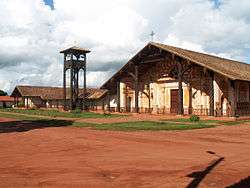 Mission church in Concepción known as part of the Jesuit Missions of Chiquitos and declared a World Heritage Site in 1990 | |
 Location of Ñuflo de Chávez Province within Bolivia | |
 Provinces of the Santa Cruz Department | |
| Coordinates: 16°00′0″S 62°00′0″W / 16.00000°S 62.00000°W | |
| Country |
|
| Department | Santa Cruz Department |
| Capital | Concepción |
| Government | |
| • Sub governor | Widen Barbery (Concepción) |
| Area | |
| • Total | 20,910 sq mi (54,150 km2) |
| Elevation | 1,627 ft (496 m) |
| Population (2001) | |
| • Total | 93,997 |
| • Density | 4/sq mi (1.7/km2) |
| • Ethnicities | Chiquitos |
| Time zone | UTC-4 (BOT) |
| Area code(s) | BO.SC.NC |
Ñuflo de Chávez[1] is one of the fifteen provinces of the Bolivian Santa Cruz Department and is situated in the northern central parts of the department. The name of the province honors the conquistador Ñuflo de Chaves (1518–1556) who founded the city of Santa Cruz de la Sierra. Its capital is Concepción. The province was created by law of September 16, 1915, during the presidency of Ismael Montes. Originally it was part of the Chiquitos Province.[2]
Location
Ñuflo de Chávez Province is located between 13° 45' and 17° 30' South and between 61° 30' and 63° 25' West. It extends over a length of 520 km from north to south, and up to 250 km from west to east.
The province is situated in the Bolivian lowlands and borders Beni Department in the north, Guarayos Province in the north-west, Obispo Santistevan Province and Ignacio Warnes Province in the south-west, Andrés Ibáñez Province and Chiquitos Province in the south, and José Miguel de Velasco Province in the east.
Division
The province comprises six municipalities which are further subdivided into cantons:[2]
| Section | Municipality | Inhabitants (2001) [3] | Seat | Inhabitants (2001) |
|---|---|---|---|---|
| 1st | Concepción Municipality | 14,522 | Concepción | 5,586 |
| 2nd | San Javier Municipality (also San Xavier Municipality) | 11,316 | San Javier | 5,538 |
| 3rd | San Ramón Municipality | 5,660 | San Ramón | 4,746 |
| 4th | San Julián Municipality | 56,206 | San Julián | 6,585 |
| 5th | San Antonio de Lomerío Municipality | 6,293 | San Antonio de Lomerío | 1,313 |
| 6th | Cuatro Cañadas Municipality | 17, 574 | Cuatro Cañadas | 4,571 |
Population
The inhabitants of the Ñuflo de Chávez Province are mainly Chiquitos whose culture roots in the fusion of their ancient customs and the influence of the Jesuit missionaries.[2] During the 2001 census the ethnic composition of the population was as follows:[4]
| Ethnic group | Concepción Municipality (%) | San Javier Municipality (%) | San Ramón Municipality (%) | San Julián Municipality (%) | San Antonio de Lomerío Municipality (%) | Cuatro Cañadas Municipality (%) |
|---|---|---|---|---|---|---|
| Quechua | 4.2 | 3.6 | 13.5 | 49.6 | 1.5 | 36.4 |
| Aymara | 1.2 | 1.4 | 2.3 | 2.2 | 0.2 | 2.2 |
| Guaraní, Chiquitos or Moxos | 67.8 | 68.4 | 31.1 | 8.6 | 87.0 | 7.8 |
| Not indigenous | 25.1 | 24.7 | 52.5 | 38.1 | 10.7 | 51.3 |
| Other indigenous groups | 1.8 | 1.9 | 0.7 | 1.5 | 0.7 | 2.4 |
The population of the province has increased by more than 100% over the recent two decades:
- 1992: 61,008 inhabitants (census)
- 2001: 93,997 inhabitants (census)
- 2005: 111,813 inhabitants (est.)[5]
- 2010: 131,856 inhabitants (est.)[6]
48.3% of the population are younger than 15 years old. (1992)
The literacy rate of the province is 72.6%.
87.3% of the population have no access to electricity, 50.4% have no sanitary facilities. (1992)
79.5% of the population are Catholics, 17.2% are Protestants. (1992)
In 1992 91.6% of the population spoke Spanish, 30.1% Quechua, 2.0% Aymara and 1.2 spoke Guaraní. During the 2001 census Spanish was spoken by 79,377 people, Quechua by 20,763, Aymara by 1,362, Guarani by 1,002, other native languages by 3,619 and foreign languages by 5,617 people. The following table shows the number of speakers per municipality:[4]
| Language | Concepción Municipality (%) | San Javier Municipality (%) | San Ramón Municipality (%) | San Julián Municipality (%) | San Antonio de Lomerío Municipality (%) | Cuatro Cañadas Municipality (%) |
|---|---|---|---|---|---|---|
| Quechua | 363 | 247 | 468 | 14,855 | 46 | 4,782 |
| Aymara simi | 120 | 104 | 75 | 804 | 7 | 252 |
| Guaraní | 53 | 142 | 25 | 682 | 14 | 86 |
| Another native | 901 | 128 | 29 | 138 | 2.221 | 202 |
| Spanish | 13,370 | 10,414 | 5,278 | 32,182 | 5.480 | 12.637 |
| Foreign | 134 | 102 | 84 | 1,209 | 199 | 3,864 |
| Only native | 138 | 31 | 46 | 2,430 | 162 | 628 |
| Native and Spanish | 1,264 | 559 | 522 | 13,469 | 2,118 | 4,558 |
| Only Spanish | 12,119 | 9,865 | 4,769 | 19,405 | 3,474 | 11,018 |
Economy
The principal economic activities are devoted to animal husbandry, dairy farming, forestry and tourism. Another important occupation is handicraft like the fabrication of hammocks, textiles, hats, bags and baskets.[2]
Environment
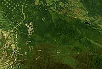
Increased agricultural use of the land has led to deforestation in the area.
See also
References
- ↑ Ñuflo de Chaves (1518-1568) was a Spanish conquistador. He is best known for founding the city of Santa Cruz de la Sierra.
- 1 2 3 4 Official site of Ñuflo de Chávez Province (Spanish)
- ↑ Instituto Nacional de Estadística, Bolivia (Spanish)
- 1 2 obd.descentralizacion.gov.bo / Observatorio Bolivia Democrático (inactive site)
- ↑ Instituto Nacional de Estadística
- ↑ Instituto Nacional de Estadística - Proyecciones