+15

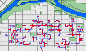
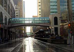
The Plus 15 or +15 Skyway network in Calgary, Alberta, Canada, is one of the world's most extensive pedestrian skywalk systems, with a total length of 18 kilometres (11 miles) and 62 bridges.[1] The system is so named because the skywalks are approximately 15 feet (approximately 4.5 metres) above street level. (Some Plus 15 skywalks are multi-level, with higher levels being referred to as +30s and +45s.)
History
The system was conceived and designed by architect Harold Hanen, who worked for the Calgary Planning Department from 1966 to 1969. This development earned him the 1970 Vincent Massey Award for Merit in Urban Planning.
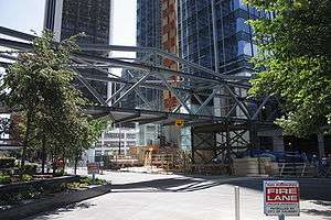
Opening in 1970, the +15 network has expanded to include 59 enclosed bridges connecting dozens of downtown Calgary buildings. The central core of the system is a series of enclosed shopping centres, and the city's flagship department stores.
New developments were required to connect to the walkway system; in exchange for this, they were offered more floorspace (the "bonus density"). When not physically able to connect to nearby buildings, developers contribute to the "Plus 15 Fund", managed by the city, used to finance other missing connections.[2]
Impact
The system has been identified with a decline in street life in the Downtown Commercial Core.[3] Street life is instead concentrated on streets (such as Stephen Avenue) or in neighbourhoods where there are no bridges (such as Eau Claire and the Beltline).
In 1998, the city began to re-evaluate the system.[3] Part of the goal of these studies was reinvigorating decreased daytime street life on some downtown streets. The possibility of limiting expansion to encourage more pedestrian street traffic was raised. The system's bridges are integral to the buildings they serve. City planning by-laws now confer tax credits to owners who connect new buildings to the system. Businesses and the general public make extensive use of the system's enhanced flow of human traffic.
List of connected buildings
- 333 5th Avenue
- 444 7th Avenue
- 505 3rd Street
- 606 4th Street
- 635 8th Avenue
- 715 5th Avenue
- 736 6th Avenue
- 840 7th Avenue
- Alberta Energy Utilities Board
- Altius Centre
- Andrew Davison Building
- Aquitaine Tower
- Atrium I
- Atrium II
- Bank of Canada
- Bankers Court
- Bankers Hall
- Banker's Hall Parkade
- Bantrel Tower
- Bow Parkade
- Bow Valley College
- Bow Valley Square
- BP Centre
- Brookfield Place (Calgary)
- Calgary Board of Education
- Calgary House
- Calgary Marriott Hotel
- Calgary Place
- Calgary Tower
- Canada Place
- Canadian Fina Building
- Canterra Tower
- Carter House
- Centennial Parkade
- Centennial Place
- Centre Four
- Century Park Place
- Chamber of Commerce
- Chevron Plaza
- City Centre Parkade
- City Hall
- City/Omni Building
- Convention Centre North
- Convention Centre South
- Core Shopping Centre (Formerly TD Square/Calgary Eaton Centre)
- Daon Building
- Delta Bow Valley Inn
- Devonian Gardens
- Dome Tower
- Dominion Centre
- Eau Claire Place II
- Eighth Avenue Place
- Elveden Centre
- Emerson Centre
- Encana Place
- Encor Place
- Epcore Centre
- Ernst and Young Tower
- Fairmont Palliser Hotel
- Fifth and Fifth
- Fifth Avenue Place
- First Alberta Place
- First Canadian Centre
- Fourth and Fourth
- Fracmaster Tower
- Glenbow Museum
- Gulf Canada Square
- Hanover Place
- Harry Hayes Government of Canada
- Hawthorn Hotel and Suites
- Hollinsworth Building
- Holt Renfrew Department Store
- Home Oil Tower
- Hyatt Regency Hotel
- Intact Place
- International Hotel
- Iveagh House
- J.J. Bowen Building
- Jamieson Place
- Lancaster Building
- Life Plaza
- Livingston Place
- London House
- Mobil Tower
- Monenco Place
- Municipal Building
- Nexen Building
- Northland Building
- Northland Place
- Palliser South
- Palliser Square
- Panarctic Centre
- Pertogen Building
- Petex Building
- Petroleum Building
- Place 800
- Old Police Headquarters Building
- Provincial Court
- Ramada Hotel
- Rocky Mountain Court
- Rocky Mountain Plaza
- Roslyn Building
- Royal Bank
- Sandman Inn
- Sanjel Building
- Scotia Bank Tower
- Scotia Centre
- Selkirk House
- Shell Centre
- Sheraton Suites
- St. Regis Hotel
- Standard Life
- Stock Exchange Tower
- Suncor Energy Centre
- Sun Life Plaza
- TD Canada Trust Tower
- TELUS House Calgary
- The Bay Department Store
- The Bow
- TransCanada Tower
- Trimac House
- Watermark Tower
- Western Canadian Place
- Western Union
- Westin Hotel
- Workers Compensation Board Office
- Y.W.C.A.
In popular culture
The Plus 15 is one of the central plot elements in the 2000 film Waydowntown, directed by Gary Burns.
See also
References
- ↑ Archived 2013-09-21 at Archive.is City of Calgary - Calgary's +15 Skywalk
- ↑ City of Calgary - Plus 15 System
- 1 2 "+15 User Survey", a City of Calgary study published in 1998
- ↑ Building List from plus15.ca Archived 2008-06-04 at the Wayback Machine.
External links
| Landmarks | |
|---|---|
| Attractions | |
| Venues | |
| Parks | |
| Malls | |
| Recreation | |
Coordinates: 51°2′50.05″N 114°4′8.19″W / 51.0472361°N 114.0689417°W