Wokingham (district)
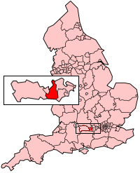
Wokingham is een unitary authority en een district in de Engelse regio South East England (ceremonieel graafschap Berkshire) en telt 168.000 inwoners. De oppervlakte bedraagt 179 km2.
| Unitaire autoriteit in Engeland | |||
 | |||
| Situering | |||
| Land | Engeland | ||
| Regio | South East England | ||
| Coördinaten | 51°24'39,50"NB, 0°50'5,73"WL | ||
| Algemeen | |||
| Oppervlakte | 178,9655[1] km² | ||
| Inwoners (2018[2]) | 167979 (939 inw./km²) | ||
| ONS-code | E06000041 | ||
| |||
De gelijknamige stad Wokingham telt circa 30.000 inwoners.
Demografie
Van de bevolking is 11,9 % ouder dan 65 jaar. De werkloosheid bedraagt 1,5 % van de beroepsbevolking (cijfers volkstelling 2001).
Het aantal inwoners steeg van ongeveer 141.100 in 1991 naar 150.229 in 2001.
Plaatsen in district Wokingham
Civil parishes in district Wokingham
Arborfield and Newland, Barkham, Charvil, Earley, Finchampstead, Remenham, Ruscombe, Shinfield, Sonning, St. Nicholas, Hurst, Swallowfield, Twyford, Wargrave, Winnersh, Wokingham, Wokingham Without, Woodley.
Bronnen, noten en/of referenties
|
This article is issued from
Wikipedia.
The text is licensed under Creative
Commons - Attribution - Sharealike.
Additional terms may apply for the media files.