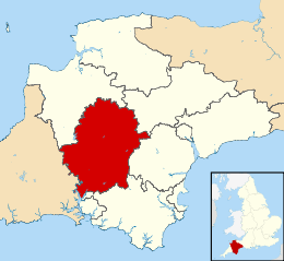
West Devon
West Devon is een Engels district in het shire-graafschap (non-metropolitan county OF county) Devon en telt 55.000 inwoners. De oppervlakte bedraagt 1160 km².
| Niet-metropolitaans district in Engeland | |||
 | |||
| Situering | |||
| Land | Engeland | ||
| County | Devon | ||
| Regio | South West England | ||
| Coördinaten | 50°38'0"NB, 4°6'0"WL | ||
| Algemeen | |||
| Oppervlakte | 1159,6608[1] km² | ||
| Inwoners (2018[2]) | 55528 (48 inw./km²) | ||
| ONS-code | E07000047 | ||
| |||
Van de bevolking is 19,8% ouder dan 65 jaar. De werkloosheid bedraagt 2,4% van de beroepsbevolking (cijfers volkstelling 2001).
Plaatsen in district West Devon
Civil parishes in district West Devon
Beaworthy, Belstone, Bere Ferrers, Bondleigh, Bradstone, Bratton Clovelly, Brentor, Bridestowe, Broadwoodkelly, Buckland Monachorum, Chagford, Coryton, Dartmoor Forest, Drewsteignton, Dunterton, Exbourne, Germansweek, Gidleigh, Gulworthy, Hatherleigh, Highampton, Horrabridge, Iddesleigh, Inwardleigh, Jacobstowe, Kelly, Lamerton, Lands common to Bridestowe and Sourton CP's, Lewtrenchard, Lifton, Lydford, Mary Tavy, Marystow, Meavy, Meeth, Milton Abbot, Monkokehampton, North Tawton, Northlew, Okehampton, Okehampton Hamlets, Peter Tavy, Sampford Courtenay, Sampford Spiney, Sheepstor, Sourton, South Tawton, Spreyton, Sticklepath, Stowford, Sydenham Damerel, Tavistock, Throwleigh, Thrushelton, Walkhampton, Whitchurch.
Partnerstad
Wesseling, Nordrhein-Westfalen (sinds 1983)
Bronnen, noten en/of referenties
|