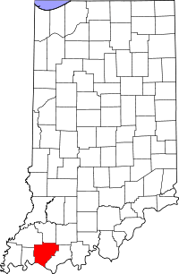
Warrick County
Warrick County is een county in de Amerikaanse staat Indiana.
| County in de Verenigde Staten | |||
 | |||
| Situering | |||
| Staat | Indiana | ||
| Coördinaten | 38°6'0"NB, 87°16'12"WL | ||
| Algemeen | |||
| Oppervlakte | 1.013 km² | ||
| - land | 995 km² | ||
| - water | 18 km² | ||
| Inwoners (2000) | 52.383 (53 inw./km²) | ||
| Overig | |||
| Zetel | Boonville | ||
| FIPS-code | 18173 | ||
| Opgericht | 1813 | ||
| Foto's | |||
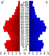 Bevolkingspiramide Warrick County | |||
| Statistieken volkstelling Warrick County | |||
| |||
De county heeft een landoppervlakte van 995 km² en telt 52.383 inwoners (volkstelling 2000). De hoofdplaats is Boonville.
Bevolkingsontwikkeling
| Historische inwonertallen | |||
|---|---|---|---|
| Jaar | Inwoners | % ± | |
| 1900 | 22.329 | ||
| 1910 | 21.911 | −1,9% | |
| 1920 | 19.862 | −9,4% | |
| 1930 | 18.230 | −8,2% | |
| 1940 | 19.435 | 6,6% | |
| 1950 | 21.527 | 10,8% | |
| 1960 | 23.577 | 9,5% | |
| 1970 | 27.972 | 18,6% | |
| 1980 | 41.474 | 48,3% | |
| 1990 | 44.920 | 8,3% | |
| 2000 | 52.383 | 16,6% | |
| Bron: (en) Historical Decennial Census Population | |||

Warrick County Courthouse
This article is issued from
Wikipedia.
The text is licensed under Creative
Commons - Attribution - Sharealike.
Additional terms may apply for the media files.